File:BahiaPernambuco RIDE PoloPetrolinaeJuazeiro.svg

Size of this PNG preview of this SVG file: 471 × 599 pixels. Other resolutions: 188 × 240 pixels | 377 × 480 pixels | 603 × 768 pixels | 804 × 1,024 pixels | 1,609 × 2,048 pixels | 539 × 686 pixels.
Original file (SVG file, nominally 539 × 686 pixels, file size: 1.03 MB)
Captions
Captions
Add a one-line explanation of what this file represents
Summary edit
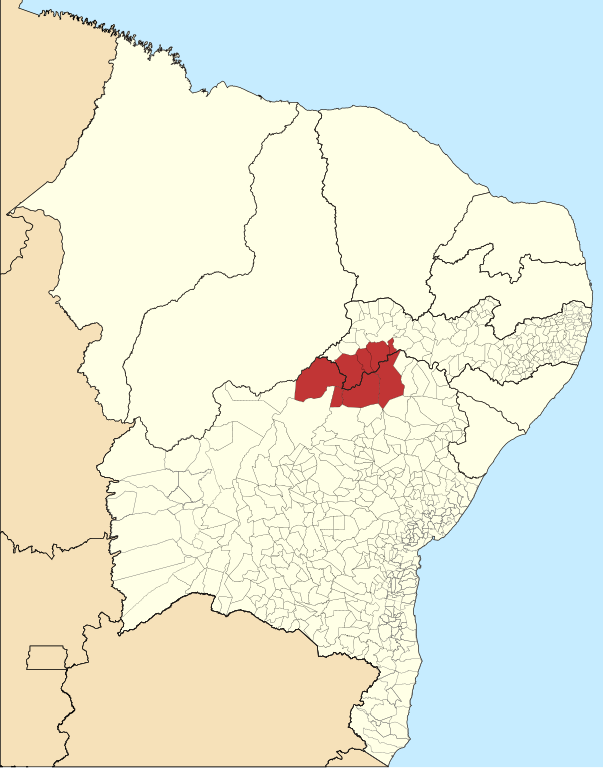
| Description |
Português: Mapa de localização da Região Administrativa Integrada de Desenvolvimento do Polo Petrolina e Juazeiro. English: Map locator of the RIDE Polo Petrolina e Juazeiro. |
| Date | (UTC) |
| Source |
This file was derived from: |
| Author |


| This is a retouched picture, which means that it has been digitally altered from its original version. The original can be viewed here: Northeast Brazil location map.svg:
|
Licensing edit
I, the copyright holder of this work, hereby publish it under the following license:
This file is licensed under the Creative Commons Attribution-Share Alike 3.0 Unported license.
- You are free:
- to share – to copy, distribute and transmit the work
- to remix – to adapt the work
- Under the following conditions:
- attribution – You must give appropriate credit, provide a link to the license, and indicate if changes were made. You may do so in any reasonable manner, but not in any way that suggests the licensor endorses you or your use.
- share alike – If you remix, transform, or build upon the material, you must distribute your contributions under the same or compatible license as the original.
Original upload log edit
This image is a derivative work of the following images:
- File:RIDE_do_Polo_Petrolina_e_Juazeiro_PE-BA.svg licensed with Cc-by-sa-3.0
- 2012-10-23T20:20:30Z Frag15 1024x1401 (994899 Bytes) User created page with UploadWizard
Uploaded with derivativeFX
File history
Click on a date/time to view the file as it appeared at that time.
| Date/Time | Thumbnail | Dimensions | User | Comment | |
|---|---|---|---|---|---|
| current | 18:15, 1 March 2016 | | 539 × 686 (1.03 MB) | Frag15 (talk | contribs) | ... |
| 18:06, 1 March 2016 |  | 539 × 686 (1.02 MB) | Frag15 (talk | contribs) | new map | |
| 13:04, 26 October 2012 |  | 1,113 × 1,065 (1.27 MB) | Frag15 (talk | contribs) | zoom | |
| 23:34, 25 October 2012 |  | 1,116 × 1,068 (987 KB) | Frag15 (talk | contribs) | ... | |
| 23:16, 25 October 2012 |  | 1,116 × 1,070 (967 KB) | Frag15 (talk | contribs) | ... | |
| 23:00, 25 October 2012 |  | 1,116 × 1,070 (968 KB) | Frag15 (talk | contribs) | Legenda | |
| 20:43, 25 October 2012 |  | 1,116 × 1,070 (950 KB) | Luan (talk | contribs) | == {{int:filedesc}} == {{Information |Description={{pt|1=Mapa de localização da Região Administrativa Integrada de Desenvolvimento do Polo Petrolina e Juazeiro.... |
You cannot overwrite this file.
File usage on Commons
There are no pages that use this file.
File usage on other wikis
The following other wikis use this file:
- Usage on de.wikipedia.org
- Usage on es.wikipedia.org
- Usage on it.wikipedia.org
- Usage on pt.wikipedia.org
- Usage on ru.wikipedia.org