File:Bahnstrecke Ostrov nad Ohří–Jáchymov.png

Size of this preview: 313 × 600 pixels. Other resolutions: 125 × 240 pixels | 250 × 480 pixels | 640 × 1,226 pixels.
Original file (640 × 1,226 pixels, file size: 375 KB, MIME type: image/png)
Captions
Captions
Add a one-line explanation of what this file represents
Summary edit
| Description |
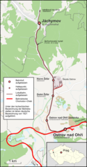
Deutsch: Karte der Bahnstrecke Ostrov nad Ohří–Jáchymov in Tschechien |
| Date | |
| Source |
Own work Map was created using:
|
| Author | |
| Permission (Reusing this file) |
Map data (c) OpenStreetMap (and) contributors, CC-BY-SA |
Licensing edit
This file is licensed under the Creative Commons Attribution-Share Alike 2.0 Generic license.
- You are free:
- to share – to copy, distribute and transmit the work
- to remix – to adapt the work
- Under the following conditions:
- attribution – You must give appropriate credit, provide a link to the license, and indicate if changes were made. You may do so in any reasonable manner, but not in any way that suggests the licensor endorses you or your use.
- share alike – If you remix, transform, or build upon the material, you must distribute your contributions under the same or compatible license as the original.
File history
Click on a date/time to view the file as it appeared at that time.
| Date/Time | Thumbnail | Dimensions | User | Comment | |
|---|---|---|---|---|---|
| current | 18:04, 19 February 2022 | | 640 × 1,226 (375 KB) | Pechristener (talk | contribs) | Gleise bei der Skoda-Halle anders |
| 18:53, 6 March 2015 |  | 683 × 1,308 (402 KB) | Pechristener (talk | contribs) | Jáchymovský tunel (Akzent gesetzt) | |
| 22:31, 5 March 2015 |  | 683 × 1,308 (402 KB) | Pechristener (talk | contribs) | Wald um Joachimstal korr | |
| 22:04, 5 March 2015 |  | 683 × 1,308 (401 KB) | Pechristener (talk | contribs) | Bezeichnung ''Jáchymovsky tunel'' entfernt / Schlackenwerth H durch Schlackenwerth Haltestelle ersetzt / Karte in der Höhe gekürzt | |
| 21:31, 5 March 2015 |  | 683 × 1,466 (428 KB) | Pechristener (talk | contribs) | Bemerkung bzgl der verwendeten deutschen Bezeichnungen in der Legende der Karte hinzugefügt. | |
| 19:56, 5 March 2015 |  | 683 × 1,466 (420 KB) | Pechristener (talk | contribs) | die "Löcher" in der Hauptstrecke beseitigt | |
| 19:47, 5 March 2015 |  | 683 × 1,466 (423 KB) | Pechristener (talk | contribs) | Legende hinzu / Farbe der Strecken geändert / Deutsche Namen von 1921 eingesetzt | |
| 13:32, 4 March 2015 |  | 683 × 1,466 (423 KB) | Pechristener (talk | contribs) | Location map fixed | |
| 13:30, 4 March 2015 |  | 683 × 1,466 (422 KB) | Pechristener (talk | contribs) | == {{int:filedesc}} == {{Information |Description = {{de|1=Karte der Bahnstrecke Ostrov nad Ohří–Jáchymov in Tschechien}} |Source ={{own}} Map was created using: *[http://www.openst... |
You cannot overwrite this file.
File usage on Commons
The following 6 pages use this file:
- User:Chumwa/OgreBot/Public transport information/2015 March 1-10
- User:Chumwa/OgreBot/Public transport information/2022 February 19-28
- User:Chumwa/OgreBot/Transport Maps/2015 March 1-10
- User:Chumwa/OgreBot/Transport Maps/2022 February 19-28
- User:Liesel/Rail transport/2015 March 1-10
- Category:Railway line Ostrov nad Ohří – Jáchymov
File usage on other wikis
The following other wikis use this file:
- Usage on cs.wikipedia.org
- Usage on de.wikipedia.org
- Usage on pl.wikipedia.org
- Usage on www.wikidata.org