File:BaileysDamMap.jpg
BaileysDamMap.jpg (448 × 218 pixels, file size: 16 KB, MIME type: image/jpeg)
File information
Structured data
Captions
Captions
Add a one-line explanation of what this file represents
Summary edit
| DescriptionBaileysDamMap.jpg |
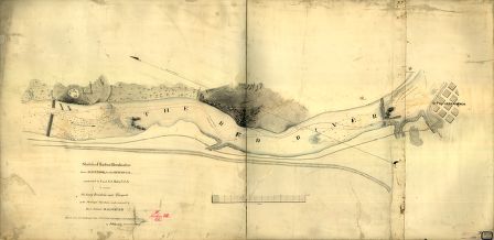
English: Sketch of the two breakwaters above Alexandria in the Red River, constructed by Lieut. Col. Bailey, U.S.A., to extricate the heavy ironclads and transports of the Mississippi Squadron, under command of Rear Admiral D. D. Porter. Drawn from Col. De Russy's map and from information received from the Admiral, by F. H. Gerdes, Asst., U.S. Coast Survey. |
| Date | |
| Source | http://memory.loc.gov/cgi-bin/query/h?ammem/gmd:@field%28NUMBER+@band%28g3992r+cw0241000%29%29 |
| Author | Gerdes, F. H. |
Licensing edit
| Public domainPublic domainfalsefalse |
| This work is from the Library of Congress. According to the library, there are no known copyright restrictions on the use of this work. |  |
File history
Click on a date/time to view the file as it appeared at that time.
| Date/Time | Thumbnail | Dimensions | User | Comment | |
|---|---|---|---|---|---|
| current | 13:34, 24 July 2010 |  | 448 × 218 (16 KB) | NortyNort (talk | contribs) | {{Information |Description={{en|1=Sketch of the two breakwaters above Alexandria in the Red River, constructed by Lieut. Col. Bailey, U.S.A., to extricate the heavy ironclads and transports of the Mississippi Squadron, under command of Rear Admiral D. D. |
You cannot overwrite this file.
File usage on Commons
There are no pages that use this file.
Metadata
This file contains additional information such as Exif metadata which may have been added by the digital camera, scanner, or software program used to create or digitize it. If the file has been modified from its original state, some details such as the timestamp may not fully reflect those of the original file. The timestamp is only as accurate as the clock in the camera, and it may be completely wrong.
| _error | 0 |
|---|
