File:Balkans in 9th century.jpg
Size of this preview: 800 × 567 pixels. Other resolutions: 320 × 227 pixels | 640 × 454 pixels | 1,024 × 726 pixels | 1,195 × 847 pixels.
Original file (1,195 × 847 pixels, file size: 339 KB, MIME type: image/jpeg)
Captions
Captions
Add a one-line explanation of what this file represents
Summary edit
| Description |
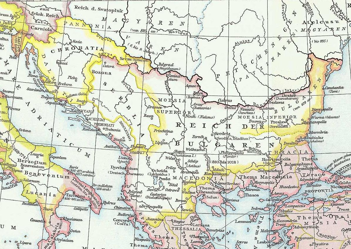
English: Map of the Balkans (part of Byzantine Empire) taken from G. Droysens Allgemeiner Historischer Handatlas, Verlag Velhagen und Klasing 1886 |
| Date | (UTC) |
| Source | G. Droysens Allgemeiner Historischer Handatlas, Verlag Velhagen und Klasing, Bielefeld / Leipzig 1886 |
| Author | Professor Gustav Droysen (Hg.), Professor G. Hertzberg (Zeichnung) |
| Permission (Reusing this file) |
This image is in the public domain because its copyright has expired. |
Licensing edit
|
This work is in the public domain in its country of origin and other countries and areas where the copyright term is the author's life plus 70 years or fewer. This work is in the public domain in the United States because it was published (or registered with the U.S. Copyright Office) before January 1, 1929. | |
| This file has been identified as being free of known restrictions under copyright law, including all related and neighboring rights. | |
Original upload log edit
The original description page was here. All following user names refer to en.wikipedia.
- 2010-11-27 18:34 Kebeta 1195×847× (347463 bytes) {{Information |Description = Map of the Balkans (part of Byzantine Empire) taken from G. Droysens Allgemeiner Historischer Handatlas, Verlag Velhagen und Klasing 1886 |Source = G. Droysens Allgemeiner Historischer Handatlas, Verlag Velhagen u
File history
Click on a date/time to view the file as it appeared at that time.
| Date/Time | Thumbnail | Dimensions | User | Comment | |
|---|---|---|---|---|---|
| current | 15:40, 16 November 2013 | | 1,195 × 847 (339 KB) | Diannaa (talk | contribs) | Full-size version from en.wiki |
| 09:00, 16 November 2013 |  | 800 × 567 (191 KB) | Jbribeiro1 (talk | contribs) | {{Information |Description={{en|Map of the Balkans (part of Byzantine Empire) taken from G. Droysens Allgemeiner Historischer Handatlas, Verlag Velhagen und Klasing 1886}} |Source=Transferred from [http://en.wikipedia.org en.wikipedia]<br/> (Original t... |
You cannot overwrite this file.
File usage on Commons
The following page uses this file:
- File:Balkans in 9th century (800px).JPG (file redirect)
.JPG&redirect=no)
File usage on other wikis
The following other wikis use this file:
- Usage on azb.wikipedia.org
- Usage on cs.wikipedia.org
- Usage on et.wikipedia.org
- Usage on pt.wikipedia.org
- Usage on sh.wikipedia.org
- Usage on zh.wikipedia.org