File:Baltų gentys 12-as amžius.svg

Size of this PNG preview of this SVG file: 549 × 600 pixels. Other resolutions: 220 × 240 pixels | 439 × 480 pixels | 703 × 768 pixels | 937 × 1,024 pixels | 1,874 × 2,048 pixels | 1,003 × 1,096 pixels.
Original file (SVG file, nominally 1,003 × 1,096 pixels, file size: 650 KB)
Captions
Captions
Add a one-line explanation of what this file represents
Summary
edit| Description |
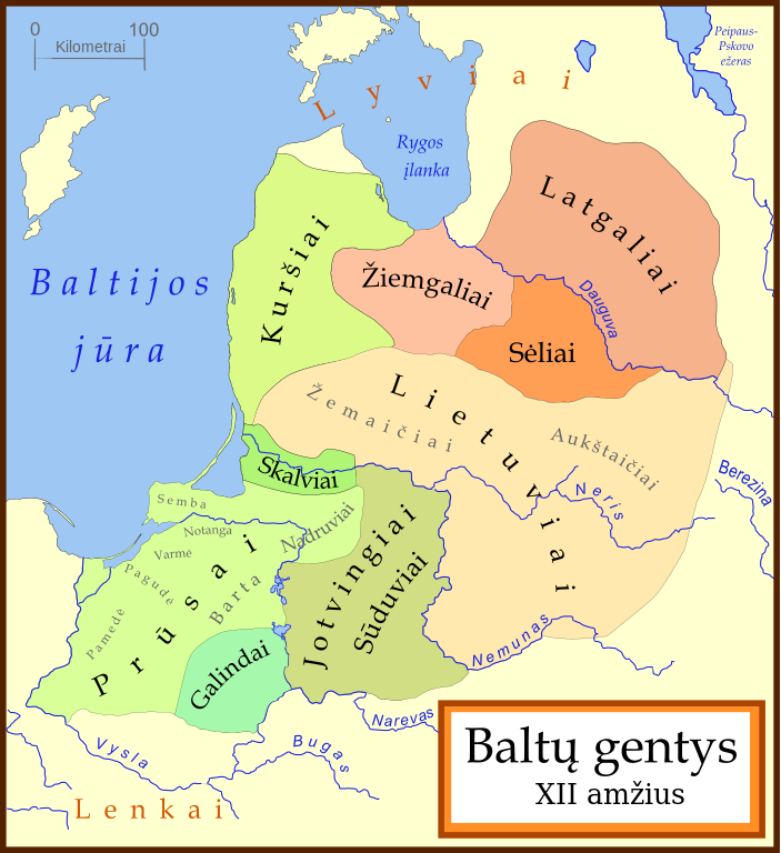
[] Català: Un mapa de les tribus bàltiques, cap al 1200 d.C. Els bàltics orientals es mostren en tons marrons mentre que els bàltics occidentals es mostren en verd. Els límits són aproximats. Aquest mapa utilitza una projecció de Mercator. Deutsch: Karte der baltischen Stämme um 1200. Ostbalten in Braun, Westbalten in Grün. Ungefähre Grenzen. English: A map of the Baltic Tribes, about 1200 AD. The Eastern Balts are shown in brown hues while the Western Balts are shown in green. The boundaries are approximate. This map uses a Mercator projection. Español: Mapa de las tribus bálticas, alrededor de 1200 d.C. Los bálticos orientales se muestran en tonos marrones, mientras que los bálticos occidentales están mostrados en verde. Las fronteras son aproximadas. Français : Une carte des peuples baltes vers 1200. Les Baltes orientaux sont représentés en marron, tandis que les Baltes occidentaux sont représentés en vert. Les frontières sont approximatives. Latviešu: Baltu cilšu apdzīvotās teritorijas aptuveni 12-13 gs. mijā. Robežas ir aptuvenas. Rietumbalti kartē iezīmēt zaļganos toņos, austrumbalti - brūnganos. Lietuvių: Baltų genčių teritorija apie 1200 metus. Vakarų baltų teritorija yra nuspalvinta žaliomis, rytų - rusvomis spalvomis. Teritorijos yra apytikslės. Magyar: A balti törzsek területei 1200 körül. A keleti-balt törzseket barnás, a nyugati-baltokat zöldes színek jelölik. Nederlands: De Baltische volkeren ca. 1200 AD. Oostbalten in bruin, Westbalten in groen. Grenzen zijn bij benadering. Polski: Mapa ukazuje plemiona Bałtyjskie, około 1200 n.e. Wschodni Bałtowie są w odcieniach brązu, zachodni - zieleni. Беларуская: Мапа балтыйскіх плямёнаў у канцы 12 — пачату 13 стагодзьдзяў. Тэрыторыі ўсходніх балтаў афарбаваныя ў карычневых адценьнях, у той жа час тэрыторыі заходніх балтаў афарбаваныя ў адценьні зялёнага колеру. Межы ўказаныя прыблізна. Русский: Карта балтийских племен в конце 12 – начале 13 веков. Территории восточных балтов окрашены в коричневых оттенках, в то время как территории западных балтов окрашены в оттенках зеленого цвета. Границы указаны приблизительно. Українська: Карта балтійських племен 1200 року. Території східних балтів фарбовані коричневими відтінтакми, а території західних балтів - зеленими. Межі народів вказані умовно. |
||
| Date | |||
| Source | Based on a map by Marija Gimbutas, published in The Balts (1963) LCC 63018018. Available at Vaidilute.com | ||
| Author | en:user:MapMaster | ||
| Permission (Reusing this file) |
GFDL | ||
| Other versions |
[]
|
.svg&lang=ca)


.svg)

.svg)


In addition to Gimbutas, other maps were also consulted:
- "Libiesi Citu Senas Latvijas Cilsu Vidu" (Livonians and other tribes of ancient Latvia 10th - 12th centuries) A map from the Latvijas Enciklopedja archive copy at the Wayback Machine
- Map at Emokykla.LT
- Another map at Emokykla.LT
This map uses a Mercator projection.
Licensing
edit
I, the copyright holder of this work, hereby publish it under the following license:

|
Permission is granted to copy, distribute and/or modify this document under the terms of the GNU Free Documentation License, Version 1.2 or any later version published by the Free Software Foundation; with no Invariant Sections, no Front-Cover Texts, and no Back-Cover Texts. A copy of the license is included in the section entitled GNU Free Documentation License. |
| This file is licensed under the Creative Commons Attribution-Share Alike 3.0 Unported license. | ||
| ||
| This licensing tag was added to this file as part of the GFDL licensing update. |
File history
Click on a date/time to view the file as it appeared at that time.
| Date/Time | Thumbnail | Dimensions | User | Comment | |
|---|---|---|---|---|---|
| current | 09:48, 25 June 2023 | | 1,003 × 1,096 (650 KB) | Obivan Kenobi (talk | contribs) | Reverted to version as of 08:44, 26 January 2021 (UTC) |
| 09:33, 25 June 2023 |  | 1,003 × 1,096 (612 KB) | Obivan Kenobi (talk | contribs) | Semba -> Sembai, Notanga -> Notangai, Barta -> Bartai, Varmė -> Varmiai, Pagudė -> Pagudėnai, Pamedė -> Pamedėnai | |
| 08:44, 26 January 2021 |  | 1,003 × 1,096 (650 KB) | Obivan Kenobi (talk | contribs) | Žiemagaliai -> Žiemgaliai, Sudūviai -> Sūduviai, 12-as amžius -> XII amžius (one more try) | |
| 08:26, 26 January 2021 |  | 1,003 × 1,096 (650 KB) | Obivan Kenobi (talk | contribs) | Žiemagaliai -> Žiemgaliai, Sudūviai -> Sūduviai, 12-as amžius -> XII amžius | |
| 16:31, 23 February 2008 |  | 1,003 × 1,096 (681 KB) | Renata3 (talk | contribs) | color fix | |
| 04:19, 30 January 2007 |  | 1,003 × 1,096 (681 KB) | MapMaster (talk | contribs) | Minor fix | |
| 14:20, 20 January 2007 |  | 1,003 × 1,096 (682 KB) | MapMaster (talk | contribs) | Baltų gentys 12-as amžius (Baltic Tribes, c. 1200 CE/AD) |
You cannot overwrite this file.
File usage on Commons
The following 19 pages use this file:
- User:Magog the Ogre/Multilingual legend/2021 January 21-31
- User:Magog the Ogre/Multilingual legend/2023 June 21-30
- File:Balten 1200.svg
- File:Balti ap 13.gs.svg
- File:Baltic Tribes c 1200-fr.svg
- File:Baltic Tribes c 1200-hu.svg
- File:Baltic Tribes c 1200-uk.svg
- File:Baltic Tribes c 1200.svg
- File:Baltic Tribes c 1200PL..svg
- File:Baltic Tribes c 1200RU.svg
- File:Baltic Tribes c 1200 ce.svg
- File:Baltic Tribes c 1200 en(multilang).svg
- File:Baltic Tribes c 1200 es.svg
- File:Baltic Tribes ca 1200 AD (et).svg
- File:Baltische Stämme um 1200.png
- File:Baltische Stämme um 1200.svg
- File:Baltų gentys 12-as amžius.svg
- File:Tribu baltiche 1200.png
- Template:Other versions/Baltic Tribes ca 1200 AD
File usage on other wikis
The following other wikis use this file:
- Usage on bat-smg.wikipedia.org
- Usage on cs.wikipedia.org
- Usage on da.wikipedia.org
- Usage on de.wikipedia.org
- Usage on el.wikipedia.org
- Usage on eo.wikipedia.org
- Usage on frp.wikipedia.org
- Usage on fr.wikipedia.org
- Discussion:Prussiens
- Wikipédia:Statistiques des anecdotes de la page d'accueil/Visibilité des anecdotes (2018)
- Wikipédia:Statistiques des anecdotes de la page d'accueil/Visibilité des anecdotes (2018)/2018 11
- Projet:Aide et accueil/Twitter/Tweets/archives/novembre 2018
- Discussion:Prussiens/LSV 16314
- Wikipédia:Le saviez-vous ?/Archives/2018
- Usage on it.wikipedia.org
- Usage on ja.wikipedia.org
- Usage on li.wikipedia.org
- Usage on lt.wikipedia.org
- Usage on nds.wikipedia.org
- Usage on no.wikipedia.org
- Usage on sv.wikipedia.org