File:Baltiškos kilmės vandenvardžių paplitimas.svg

Size of this PNG preview of this SVG file: 800 × 529 pixels. Other resolutions: 320 × 212 pixels | 640 × 424 pixels | 1,024 × 678 pixels | 1,280 × 847 pixels | 2,560 × 1,694 pixels | 1,591 × 1,053 pixels.
Original file (SVG file, nominally 1,591 × 1,053 pixels, file size: 740 KB)
Captions
Captions
Add a one-line explanation of what this file represents
Summary edit
| Description |
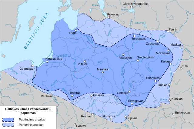
English: Map of the distribution of hydronymes of Baltic origin. The main area is dark blue, the peripheral area is light blue. In Lithuanian.
Lietuvių: Baltiškos kilmės vandenvardžių paplitimo žemėlapis |
| Date | |
| Source | Own work. According to Visuotinė lietuvių enciklopedija, using OpenStreetMap data |
| Author | Obivan Kenobi |
| SVG development |
Licensing edit
I, the copyright holder of this work, hereby publish it under the following license:
This file is licensed under the Creative Commons Attribution-Share Alike 4.0 International license.
- You are free:
- to share – to copy, distribute and transmit the work
- to remix – to adapt the work
- Under the following conditions:
- attribution – You must give appropriate credit, provide a link to the license, and indicate if changes were made. You may do so in any reasonable manner, but not in any way that suggests the licensor endorses you or your use.
- share alike – If you remix, transform, or build upon the material, you must distribute your contributions under the same or compatible license as the original.
File history
Click on a date/time to view the file as it appeared at that time.
| Date/Time | Thumbnail | Dimensions | User | Comment | |
|---|---|---|---|---|---|
| current | 17:05, 31 August 2022 | | 1,591 × 1,053 (740 KB) | Obivan Kenobi (talk | contribs) | Žitomiras -> Žitomyras |
| 18:53, 30 May 2022 |  | 1,591 × 1,053 (740 KB) | Obivan Kenobi (talk | contribs) | Uploaded own work with UploadWizard |
You cannot overwrite this file.
File usage on Commons
The following 3 pages use this file:
File usage on other wikis
The following other wikis use this file:
- Usage on ca.wikipedia.org
- Usage on diq.wikipedia.org
- Usage on en.wikipedia.org
- Usage on ku.wikipedia.org
- Usage on lt.wikipedia.org
- Usage on www.wikidata.org