File:BalticStatesBorders.svg

Size of this PNG preview of this SVG file: 721 × 593 pixels. Other resolutions: 292 × 240 pixels | 584 × 480 pixels | 934 × 768 pixels | 1,245 × 1,024 pixels | 2,490 × 2,048 pixels.
Original file (SVG file, nominally 721 × 593 pixels, file size: 229 KB)
Captions
Captions
Add a one-line explanation of what this file represents
| Description |
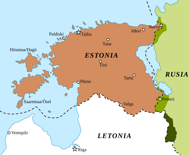
English: border changes of Estonia and Latvia between 1939 and 2001 Border changes drawn based on Goode's World Atlas, editions 1934 & 2001, RAND&McNALLY, CHICAGO
Español: Cambios territoriales en Estonia y Letonia desde el comienzo de la Segunda Guerra Mundial. |
| Date | (UTC) |
| Source | |
| Author |
|
| Other versions |
|


| This is a retouched picture, which means that it has been digitally altered from its original version. Modifications: Spanish version and map turned into svg. The original can be viewed here: Baltic states borders.jpg:
|
I, the copyright holder of this work, hereby publish it under the following licenses:
| This file is licensed under the Creative Commons Attribution-Share Alike 3.0 Unported license. | ||
| ||
| This licensing tag was added to this file as part of the GFDL licensing update. |

|
Permission is granted to copy, distribute and/or modify this document under the terms of the GNU Free Documentation License, Version 1.2 or any later version published by the Free Software Foundation; with no Invariant Sections, no Front-Cover Texts, and no Back-Cover Texts. A copy of the license is included in the section entitled GNU Free Documentation License. |
You may select the license of your choice.
Original upload log edit
This image is a derivative work of the following images:
- File:Baltic_states_borders.jpg licensed with Cc-by-sa-3.0-migrated, GFDL
- 2008-07-25T23:35:54Z Mardus 721x593 (223956 Bytes) {{Information |Description={{en|Border changes of Estonia and Latvia between 1939 and 2001}} |Source= |Date= |Author= |Permission= |other_versions= }}
- 2005-10-03T04:39:35Z Kallgan 721x593 (69021 Bytes) border changes of Estonia and Latvia between 1939 and 2001 {{GFDL-self}}
Uploaded with derivativeFX
File history
Click on a date/time to view the file as it appeared at that time.
| Date/Time | Thumbnail | Dimensions | User | Comment | |
|---|---|---|---|---|---|
| current | 11:03, 6 February 2022 | | 721 × 593 (229 KB) | Rowanwindwhistler (talk | contribs) | New colours for Latvian territory handed over to Russia |
| 10:59, 6 February 2022 |  | 721 × 593 (226 KB) | Rowanwindwhistler (talk | contribs) | Improved version. Lines closer to the original ones, lighter colours. Fake text added | |
| 06:39, 11 August 2015 |  | 721 × 593 (115 KB) | Rowanwindwhistler (talk | contribs) | Sea border | |
| 06:36, 11 August 2015 |  | 721 × 593 (114 KB) | Rowanwindwhistler (talk | contribs) | Colours from http://colorbrewer2.org/ & https://en.wikipedia.org/wiki/Wikipedia:WikiProject_Maps/Conventions | |
| 22:47, 8 January 2010 |  | 721 × 593 (93 KB) | Rowanwindwhistler (talk | contribs) | {{Information |Description={{en|1=border changes of Estonia and Latvia between 1939 and 2001 Border changes drawn based on Goode's World Atlas, editions 1934 & 2001, RAND&McNALLY, CHICAGO}} {{es|1=Cambios territoriales en Estonia y Letonia desde el comie |
You cannot overwrite this file.
File usage on Commons
The following 4 pages use this file:
File usage on other wikis
The following other wikis use this file:
- Usage on ca.wikipedia.org
- Usage on es.wikipedia.org
- Usage on ja.wikipedia.org
- Usage on lt.wikipedia.org