File:Barne Road, St Budeaux - geograph.org.uk - 1709924.jpg

Size of this preview: 450 × 600 pixels. Other resolutions: 180 × 240 pixels | 480 × 640 pixels.
Original file (480 × 640 pixels, file size: 93 KB, MIME type: image/jpeg)
Captions
Captions
Add a one-line explanation of what this file represents
Summary edit
| Description |
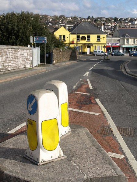
English: Barne Road, St Budeaux. The road crosses two railway lines in quick succession to leave the Barne Barton estate and reach the shops on Wolseley Road. As the blue notices indicate, this means that the bridge gives access to two different stations on different lines, which must be unusual. On the left is a path to St Budeaux Victoria Road (see 816909), on the Tamar Valley Line to Gunnislake, while off to the near right is St Budeaux Ferry Road station (see 816905), on the Cornish Main Line. Perhaps that's why there are two road bollards so close together. |
| Date | |
| Source | From geograph.org.uk |
| Author | Derek Harper |
| Attribution (required by the license) | Derek Harper / Barne Road, St Budeaux / |
| Camera location | | View this and other nearby images on: OpenStreetMap |
|---|
_heading:45.00&language=en)
| Object location | | View this and other nearby images on: OpenStreetMap |
|---|
_heading:45.00&language=en)
Licensing edit

|
This image was taken from the Geograph project collection. See this photograph's page on the Geograph website for the photographer's contact details. The copyright on this image is owned by Derek Harper and is licensed for reuse under the Creative Commons Attribution-ShareAlike 2.0 license.
|
This file is licensed under the Creative Commons Attribution-Share Alike 2.0 Generic license.
Attribution: Derek Harper
- You are free:
- to share – to copy, distribute and transmit the work
- to remix – to adapt the work
- Under the following conditions:
- attribution – You must give appropriate credit, provide a link to the license, and indicate if changes were made. You may do so in any reasonable manner, but not in any way that suggests the licensor endorses you or your use.
- share alike – If you remix, transform, or build upon the material, you must distribute your contributions under the same or compatible license as the original.
File history
Click on a date/time to view the file as it appeared at that time.
| Date/Time | Thumbnail | Dimensions | User | Comment | |
|---|---|---|---|---|---|
| current | 04:22, 5 March 2011 | | 480 × 640 (93 KB) | GeographBot (talk | contribs) | == {{int:filedesc}} == {{Information |description={{en|1=Barne Road, St Budeaux The road crosses two railway lines in quick succession to leave the Barne Barton estate and reach the shops on Wolseley Road. As the blue notices indicate, this means that the |
You cannot overwrite this file.
File usage on Commons
There are no pages that use this file.