File:Barrages Rive + Piney, 42.jpg

Original file (1,136 × 852 pixels, file size: 252 KB, MIME type: image/jpeg)
Captions
Captions
Summary edit
| Description |
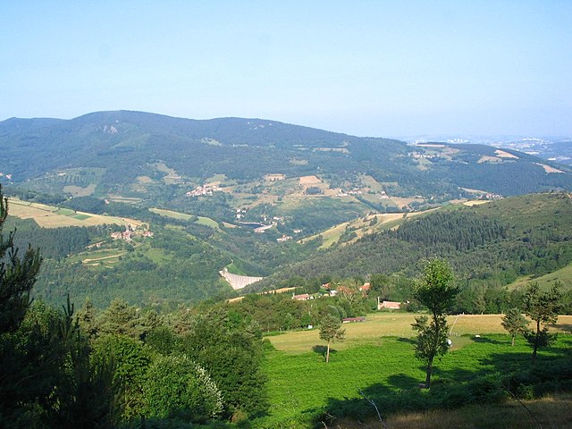
Français : Alignés, les barrages de la Rive (vol. réservoir: 1,48 million de m3) et du Piney.
Ouvrages aux dimensions (h: 47 m) et fonction similaires, à savoir fournir de l’eau potable à la ville de Saint-Chamond, ils sont toutefois bâtis à 2 époques différentes: 1870 pour le 1er, milieu des années 1950 pour le 2nd, lorsqu’on envisageait une explosion de la demande industrielle, dans un contexte de croissance économique. Chose qui ne se produira pas. Au fil du temps et des inspections, des malfaçons sont par ailleurs découvertes dans le mur du Piney, compromettant la sécurité d’ensemble. Tirant la leçon de la catastrophe de Malpasset, en 1959, les pouvoirs publics décident l’abandon progressif de l’ouvrage. Le mur est aujourd’hui percé à sa base et la retenue, définitivement vidée. Saint-Chamond possède un 3e barrage, actif, l’impressionnant Soulages et son architecture béton à voûtes multiples (1970, soit pile un siècle après Rive...), haut de 40 m pour un volume retenu à 2,6 millions de m3. |
| Date | |
| Source | Own work |
| Author | Nanzig |
| Camera location | | View this and other nearby images on: OpenStreetMap |
|---|
Licensing edit
- You are free:
- to share – to copy, distribute and transmit the work
- to remix – to adapt the work
- Under the following conditions:
- attribution – You must give appropriate credit, provide a link to the license, and indicate if changes were made. You may do so in any reasonable manner, but not in any way that suggests the licensor endorses you or your use.
- share alike – If you remix, transform, or build upon the material, you must distribute your contributions under the same or compatible license as the original.
| Annotations | This image is annotated: View the annotations at Commons |
File history
Click on a date/time to view the file as it appeared at that time.
| Date/Time | Thumbnail | Dimensions | User | Comment | |
|---|---|---|---|---|---|
| current | 15:20, 20 January 2018 | | 1,136 × 852 (252 KB) | Nanzig (talk | contribs) | User created page with UploadWizard |
You cannot overwrite this file.
File usage on Commons
There are no pages that use this file.