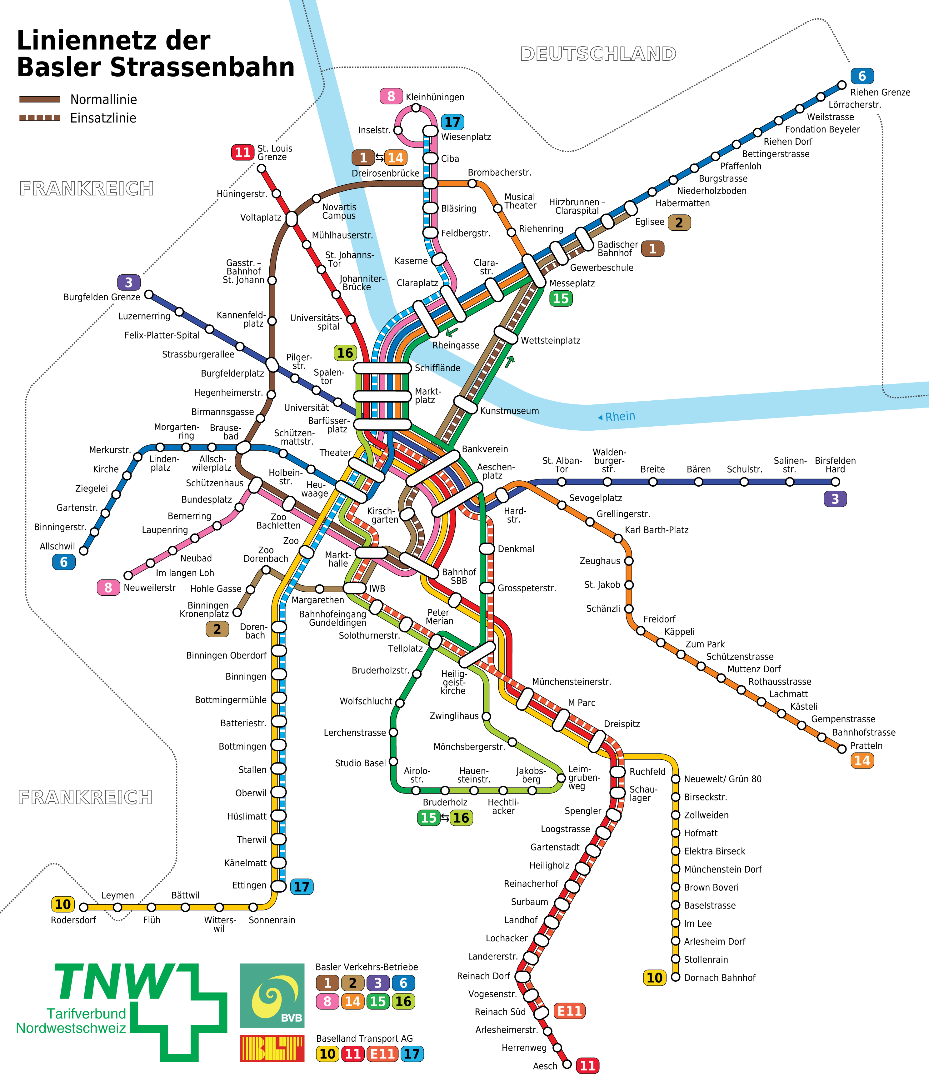
File:Basel - Straßenbahn - Netzplan.png
Size of this preview: 510 × 599 pixels. Other resolutions: 204 × 240 pixels | 408 × 480 pixels | 653 × 768 pixels | 871 × 1,024 pixels | 1,743 × 2,048 pixels | 2,973 × 3,494 pixels.
Original file (2,973 × 3,494 pixels, file size: 1.1 MB, MIME type: image/png)
Captions
Captions
Add a one-line explanation of what this file represents
| Description |
|
||||
| Date | |||||
| Source |
Self made, inspired by a transport map from the TNW. The following logos were used: BVB, BLT. The TNW logo was reworked by myself. |
||||
| Author | Maximilian Dörrbecker (Chumwa) | ||||
| Permission (Reusing this file) |
I, the copyright holder of this work, hereby publish it under the following license: This file is licensed under the Creative Commons Attribution-Share Alike 2.5 Generic license.
Sie dürfen das Bild zu den folgenden Bedingungen nutzen:
|
||||
| Other versions |
|


File history
Click on a date/time to view the file as it appeared at that time.
| Date/Time | Thumbnail | Dimensions | User | Comment | |
|---|---|---|---|---|---|
| current | 07:06, 23 September 2017 | | 2,973 × 3,494 (1.1 MB) | Chumwa (talk | contribs) | corr |
| 05:17, 14 February 2008 |  | 2,973 × 3,494 (1.06 MB) | Chumwa (talk | contribs) | Überschrift auf Wunsch von Wladyslaw abgeändert. | |
| 19:27, 12 February 2008 |  | 2,973 × 3,494 (1.06 MB) | Chumwa (talk | contribs) | Korrekturanmerkungen von Wladyslaw eingearbeitet: Rhein mit Fließrichtung ausgestattet, Linienende Riehen und Haltestellennamen Neuewelt/ Grün 80 korrigiert, Haltestellensignet Messeplatz etwas vergrößert | |
| 07:06, 12 February 2008 |  | 2,973 × 3,494 (1.06 MB) | Chumwa (talk | contribs) | Darstellung der Verkehrsträger der einzelnen Linien mit aufgenommen | |
| 23:00, 11 February 2008 |  | 2,973 × 3,494 (1.04 MB) | Chumwa (talk | contribs) | verbesserte Darstellung der Einsatzlinien | |
| 22:30, 11 February 2008 |  | 2,973 × 3,494 (1.04 MB) | Chumwa (talk | contribs) | Einsatzlinien differenziert dargestellt | |
| 21:51, 11 February 2008 |  | 2,973 × 3,494 (1.02 MB) | Chumwa (talk | contribs) | some enhencements | |
| 19:13, 11 February 2008 |  | 2,973 × 3,494 (1.01 MB) | Chumwa (talk | contribs) | {{Information |Description= *{{ de }} Karte: Schema-Netzplan der Straßenbahn Basel *{{ en }} Map: Basel streetcar network *{{ fr }} Plan: Réseau des tramways de Bâle |Source=Self made, based on a transport map from the CTS |Date=Feb. 2008 |Author= [[:d |
You cannot overwrite this file.
File usage on Commons
The following 11 pages use this file:
- User:Chumwa/Gallery
- User:Chumwa/OgreBot/Potential transport maps/2017 September 21-30
- User:Chumwa/OgreBot/Public transport information/2017 September 21-30
- User:Chumwa/OgreBot/Transport Maps/2017 September 21-30
- User:Chumwa/OgreBot/Travel and communication maps/2017 September 21-30
- File:Basel - Regio-S-Bahn Basel - Netzplan.jpg
- File:Basel - Regio-S-Bahn Basel - Netzplan (mit Hintergrund).jpg
- File:Basel - Straßenbahn - Netzplan-2.svg
- File:Basel - Straßenbahn - Netzplan.png
- File:Basel - Straßenbahn - Netzplan.svg
- File:Basel - Straßenbahnnetzplan.png
.jpg)
File usage on other wikis
The following other wikis use this file:
- Usage on de.wikipedia.org