File:Basse Mesopotamie PB.PNG
No higher resolution available.
Basse_Mesopotamie_PB.PNG (440 × 393 pixels, file size: 157 KB, MIME type: image/png)
Captions
Captions
Add a one-line explanation of what this file represents
| Description |
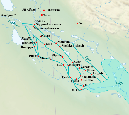
English: Location map of the main cities of Lower Mesopotamia during the Old Babylonian period (2004-1595 BC). With the approximate course of the rivers and the ancient shoreline of the Gulf. Français : Carte de localisation des principales villes de la Basse Mésopotamie durant la période paléo-babylonienne (2004-1595 av. J.-C.). Avec le tracé approximatif des fleuves et l'ancien trait de côte du Golfe. |
| Date | (UTC) |
| Source | |
| Author |
|
| This is a retouched picture, which means that it has been digitally altered from its original version. Modifications: Ajout des villes, du tracé des fleuves antiques et du trait de côte du Golfe.. The original can be viewed here: Near East topographic map-blank.svg:
|
I, the copyright holder of this work, hereby publish it under the following licenses:
This file is licensed under the Creative Commons Attribution-Share Alike 3.0 Unported, 2.5 Generic, 2.0 Generic and 1.0 Generic license.
- You are free:
- to share – to copy, distribute and transmit the work
- to remix – to adapt the work
- Under the following conditions:
- attribution – You must give appropriate credit, provide a link to the license, and indicate if changes were made. You may do so in any reasonable manner, but not in any way that suggests the licensor endorses you or your use.
- share alike – If you remix, transform, or build upon the material, you must distribute your contributions under the same or compatible license as the original.

|
Permission is granted to copy, distribute and/or modify this document under the terms of the GNU Free Documentation License, Version 1.2 or any later version published by the Free Software Foundation; with no Invariant Sections, no Front-Cover Texts, and no Back-Cover Texts. A copy of the license is included in the section entitled GNU Free Documentation License. |
You may select the license of your choice.
Original upload log edit
This image is a derivative work of the following images:
- File:Near_East_topographic_map-blank.svg licensed with Cc-by-sa-3.0,2.5,2.0,1.0, GFDL
- 2009-08-18T18:31:37Z Sémhur 2425x1581 (2442670 Bytes) 3 - New try
- 2009-08-17T15:39:22Z Sémhur 2425x1581 (1815374 Bytes) 2 - With the background...
- 2009-08-17T15:37:36Z Sémhur 2425x1581 (2836 Bytes) {{Information |Description={{en|1=Blank physical map of the [[:en:Near East|Near East]]}} {{fr|1=Carte physique vierge du [[:fr:Proche-Orient|Proche-Orient]].}} |Source={{own}} |Author=[[User:Sémhur|Sémhur]] |Date=2008-08-1
Uploaded with derivativeFX
File history
Click on a date/time to view the file as it appeared at that time.
| Date/Time | Thumbnail | Dimensions | User | Comment | |
|---|---|---|---|---|---|
| current | 10:21, 26 February 2023 | | 440 × 393 (157 KB) | Zunkir (talk | contribs) | opacité, cours d'eau, villes |
| 21:02, 10 December 2017 |  | 1,026 × 736 (588 KB) | Bulldoc (talk | contribs) | aggiunta Umma ed il terreno della Guedemma, causa della guerra con Lagash | |
| 01:17, 13 January 2017 |  | 1,026 × 736 (814 KB) | Kindattu2004 (talk | contribs) | Cities of Kisurra and Kutalla added | |
| 16:59, 28 September 2010 |  | 1,026 × 736 (826 KB) | Zunkir (talk | contribs) | {{Information |Description={{en|1=Location map of the main cities of Lower Mesopotamia during the paleo-babylonian period (2004-1595 BC). With the approximate course of the rivers and the ancient shoreline of the Gulf.}} {{fr|1=Carte de localisation des p |
You cannot overwrite this file.
File usage on Commons
There are no pages that use this file.
File usage on other wikis
The following other wikis use this file:
- Usage on ar.wikipedia.org
- Usage on arz.wikipedia.org
- Usage on ca.wikipedia.org
- Usage on ceb.wikipedia.org
- Usage on en.wikipedia.org
- Usage on es.wikipedia.org
- Usage on fr.wikipedia.org
- Usage on it.wikipedia.org
- Usage on pl.wikipedia.org
View more global usage of this file.