File:Bastilles.Kingston.sur.Hull.png

Size of this preview: 491 × 600 pixels. Other resolutions: 196 × 240 pixels | 393 × 480 pixels | 663 × 810 pixels.
Original file (663 × 810 pixels, file size: 49 KB, MIME type: image/png)
Captions
Captions
Add a one-line explanation of what this file represents
Summary edit
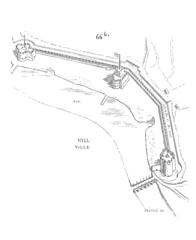
English: Plan of the line of forts of Kingston upon Hull in Dictionnaire raisonné de l’architecture française du XIe au XVIe siècle - Tome 1, Architecture militaire derived from the image by M.H Parker in "Some Account of Domestic Architecture in England from Edward I to Richard II" (1853), page 164 (archived versions : https://archive.org/details/accountdomesticarch00park p.164 or https://archive.org/details/someaccountdome03parkgoog)
The image in Parkers book is from Wenceslas Hollars map of Hull (see File:Wenceslas Hollar - Hull.jpg)
Français : Plan de la ligne des bastilles de Kingston sur Hull reproduit par M.H. Parker.
Issu du Dictionnaire raisonné de l'architecture française du XIe au XVIe siècle, par Eugène Viollet-Le-Duc, 1856.
This image comes from Dictionary of French Architecture from 11th to 16th Century (1856) by Eugène Viollet-le-Duc (1814-1879).
|
 |
|
This work is in the public domain in its country of origin and other countries and areas where the copyright term is the author's life plus 100 years or fewer. This work is in the public domain in the United States because it was published (or registered with the U.S. Copyright Office) before January 1, 1929. | |
| This file has been identified as being free of known restrictions under copyright law, including all related and neighboring rights. | |
File history
Click on a date/time to view the file as it appeared at that time.
| Date/Time | Thumbnail | Dimensions | User | Comment | |
|---|---|---|---|---|---|
| current | 05:32, 3 September 2005 | | 663 × 810 (49 KB) | BuzzWikimedia (talk | contribs) | Plan de la ligne des bastilles de Kingston sur Hull reproduit par M.H. Parker. Issu du Dictionnaire raisonné de l'architecture française du XI<sup>e</sup> au XVI<sup>e</sup> siècle, par Eugène Viollet-Le-Duc, 1856. <br><br> |
You cannot overwrite this file.
File usage on Commons
There are no pages that use this file.
File usage on other wikis
The following other wikis use this file:
- Usage on de.wikipedia.org
- Usage on en.wikipedia.org
- Usage on fr.wikisource.org