File:Attila in Gaul 451CE-fr.svg

Original file (SVG file, nominally 1,280 × 977 pixels, file size: 420 KB)
Captions
Captions
Summary edit
| Description |
Deutsch: Dies ist die deutschsprachige Diagrammversion, andere sind unten angegeben.
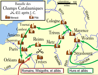
Das Diagramm zeigt die wahrscheinlichen Wege, die von den Hunnen bei ihrer Invasion Galliens 451 benutzt wurden, und die Schicksale der Städte auf ihrem Weg. English: An historical map showing the Hun invasion of Gaul in 451 CE (AD), leading to the Battle of Chalons. The generally accepted routes are shown, along with the larger cities threatened or sacked by the Huns.
Français : Une carte historique montrant l'invasion de la Gaule par les Huns en 451 apr. J.-C., et la bataille des champs Catalauniques. Les itinéraires probables sont indiqués, avec les plus grandes villes menacées ou pillées par les Huns.
Les différentes sources fournissent des informations contradictoires sur la survenue ou non du pillage de certaines villes, en particulier pour la ville de Trèves. Italiano: Carta storica che descrive l'invasione della Gallia da parte degli Unni nel 451 d.C., e la battaglia dei Campi Catalaunici. Sono mostrati i probabili itinerari, e le città conquistate o risparmiate dagli Unni. |
| Date | 30 October 2006 (original upload date) |
| Source | No machine-readable source provided. Own work assumed (based on copyright claims). |
| Author | No machine-readable author provided. MapMaster assumed (based on copyright claims). |
| Other versions |
[]
|


Other versions or similar maps edit
- There is an English language map here.
- Voici la version française.
- Hier ist die deutsche Version.
- Qui è una versione di lingua italiana.
References edit
- Fuller, J.F.C., "The Battle Of Chalons," A Military History of the Western World: From he Earliest Times To The Battle of Lepanto, Da Capo Press, New York, vol. 1. pp. 282-301 ISBN 0-306-80304-6. archive copy at the Wayback Machine
- Attila the Hun and the Battle of Chalons by Arther Ferrill archive copy at the Wayback Machine
- Various other sources including the Catholic Encyclopedia articles on the various cities.
Various sources give conflicting information on whether some cities were sacked, in particular Trier. Man says "no", while Ferrill says "yes". Most other sources agree with Ferrill. There are also several cities southeast of Troyes which were said to have been sacked, including Auxerre, Besancon, and Langres.
In order to be as understandable as possible to the average reader, I have used the modern-day names of the towns, rather than the names used in 451 CE.
Licensing edit

|
Permission is granted to copy, distribute and/or modify this document under the terms of the GNU Free Documentation License, Version 1.2 or any later version published by the Free Software Foundation; with no Invariant Sections, no Front-Cover Texts, and no Back-Cover Texts. A copy of the license is included in the section entitled GNU Free Documentation License. |
| This file is licensed under the Creative Commons Attribution-Share Alike 3.0 Unported license. | ||
| ||
| This licensing tag was added to this file as part of the GFDL licensing update. |
derivative works edit
Derivative works of this file: Bataille des champs Catalauniques sr.svg
File history
Click on a date/time to view the file as it appeared at that time.
| Date/Time | Thumbnail | Dimensions | User | Comment | |
|---|---|---|---|---|---|
| current | 17:52, 28 July 2010 | | 1,280 × 977 (420 KB) | Sting (talk | contribs) | Further translations; some minor corrections |
| 16:10, 30 October 2006 |  | 1,292 × 989 (533 KB) | MapMaster (talk | contribs) | Une carte historique montrant l'invasion d'hun de la Gaule dans 451 AD, et la bataille des champs Catalauniques. Les itinéraires probables sont montrés, avec les villes plus grandes menacées ou pillées par les huns. ==References== *[http://www.wargam |
You cannot overwrite this file.
File usage on Commons
The following 29 pages use this file:
- Battle of Chalons
- File:Attila in Gaul 451CE-de.svg
- File:Attila in Gaul 451CE-es.svg
- File:Attila in Gaul 451CE-fr.svg
- File:Attila in Gaul 451CE-hu.svg
- File:Attila in Gaul 451CE-it.svg
- File:Attila in Gaul 451CE-lb.svg
- File:Attila in Gaul 451CE-nl.svg
- File:Attila in Gaul 451CE-pt.svg
- File:Attila in Gaul 451CE-ru.png
- File:Attila in Gaul 451CE-zh.svg
- File:Attila in Gaul 451CE.svg
- File:Bataille des champs Catalauniques.svg (file redirect)
- File:Attila in Gaul 451CE.svg
- File:Attila in Gaul 451CE-fr.svg
- File:Attila in Gaul 451CE-de.svg
- File:Attila in Gaul 451CE-it.svg
- Battle of Chalons
- File:Bataille des champs Catalauniques sr.svg
- File:Attila in Gaul 451CE-nl.svg
- File:Attila in Gaul 451CE-es.svg
- File:Attila in Gaul 451CE-pt.svg
- File:Attila in Gaul 451CE-hu.svg
- Template:Other versions/Attila in Gaul 451CE
- File:Attila in Gaul 451CE-ru.png
- File:Attila in Gaul 451CE-lb.svg
- File:Attila in Gaul 451CE-zh.svg
- File:Bataille des champs Catalauniques sr.svg
- Template:Other versions/Attila in Gaul 451CE
File usage on other wikis
The following other wikis use this file:
- Usage on bg.wikipedia.org
- Usage on fr.wikipedia.org
- Usage on kk.wikipedia.org