File:Batalla de Brunete revisada.png

Size of this preview: 726 × 600 pixels. Other resolutions: 291 × 240 pixels | 581 × 480 pixels | 930 × 768 pixels | 1,240 × 1,024 pixels | 1,634 × 1,350 pixels.
Original file (1,634 × 1,350 pixels, file size: 951 KB, MIME type: image/png)
Captions
Captions
Add a one-line explanation of what this file represents

|
This historical map image could be re-created using vector graphics as an SVG file. This has several advantages; see Commons:Media for cleanup for more information. If an SVG form of this image is available, please upload it and afterwards replace this template with
{{vector version available|new image name}}.
It is recommended to name the SVG file “Batalla de Brunete revisada.svg”—then the template Vector version available (or Vva) does not need the new image name parameter. |
Summary edit
| Description |
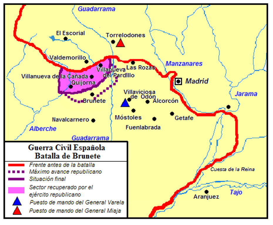
Español: Mapa de la zona donde se desarrolló la Batalla de Brunete. Se indica la línea de máxima penetración de las fuerzas republicanas y la situación final, correspondiente al día 27 de julio, cuando queda estabilizado el frente. |
| Date | |
| Source | Own work |
| Author | Modificación de File:Batalla de Brunete.png, by Paco, hecha por FPino |
Licensing edit
I, the copyright holder of this work, hereby publish it under the following licenses:

|
Permission is granted to copy, distribute and/or modify this document under the terms of the GNU Free Documentation License, Version 1.2 or any later version published by the Free Software Foundation; with no Invariant Sections, no Front-Cover Texts, and no Back-Cover Texts. A copy of the license is included in the section entitled GNU Free Documentation License. |
| This file is licensed under the Creative Commons Attribution-Share Alike 3.0 Unported license. | ||
| ||
| This licensing tag was added to this file as part of the GFDL licensing update. |
This file is licensed under the Creative Commons Attribution 2.5 Generic license.
- You are free:
- to share – to copy, distribute and transmit the work
- to remix – to adapt the work
- Under the following conditions:
- attribution – You must give appropriate credit, provide a link to the license, and indicate if changes were made. You may do so in any reasonable manner, but not in any way that suggests the licensor endorses you or your use.
You may select the license of your choice.
File history
Click on a date/time to view the file as it appeared at that time.
| Date/Time | Thumbnail | Dimensions | User | Comment | |
|---|---|---|---|---|---|
| current | 18:18, 25 December 2006 | | 1,634 × 1,350 (951 KB) | EfePino (talk | contribs) | {{Information |Description=Mapa de la zona donde se desarrolló la Batalla de Brunete. Se indica la línea de máxima penetración de las fuerzas republicanas y la situación final, correspondiente al día 27 de julio, cuando queda estabilizado el frente. |
You cannot overwrite this file.
File usage on Commons
The following page uses this file:
File usage on other wikis
The following other wikis use this file:
- Usage on an.wikipedia.org
- Usage on ca.wikipedia.org
- Usage on de.wikipedia.org