File:Battle of Brandywine, in which the rebels were defeated, September the 11th 1777, by the army under the command of General Sr. Wam. Howe. LOC gm71000928.jpg

Size of this preview: 453 × 599 pixels. Other resolutions: 181 × 240 pixels | 363 × 480 pixels | 581 × 768 pixels | 774 × 1,024 pixels | 1,548 × 2,048 pixels | 7,578 × 10,023 pixels.
Original file (7,578 × 10,023 pixels, file size: 11.55 MB, MIME type: image/jpeg)
Captions
Captions
Add a one-line explanation of what this file represents
Summary edit
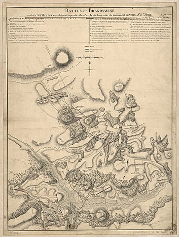
| Description |
English: Scale ca. 1:15,200. Relief shown by hachures. Manuscript, pen-and-ink and watercolor. Annotated in ink above legend to change "Reference" to the attack made by the left under the command of Lt. Genl. Earl Cornwallis. Reference to the attack made by the right under the command of His Excellency Lieutt. General Knyphausen." The words "attack made to the left" and "attack made to the right" have been crossed out, and each phrase replaced with the word "column." LC Maps of North America, 1750-1789, 1336 Available also through the Library of Congress Web site as a raster image. Vault AACR2 |
||
| Title | Battle of Brandywine, in which the rebels were defeated, September the 11th 1777, by the army under the command of General Sr. Wam. Howe. | ||
| Shelf ID | G3824.C387S3 1777 .B32 | ||
| Date | |||
| Source | https://www.loc.gov/item/gm71000928/ | ||
| Author | Faden, William | ||
| Permission (Reusing this file) |
|
||
| Other versions |
|
||
| Location | Pennsylvania · United States · Chadds Ford Region | ||
| Part of | Military Battles And Campaigns · American Memory · Catalog · Geography And Map Division · American Revolution And Its Era: Maps And Charts Of North America And The West Indies, 1750-1789 | ||
| Subject | Early Maps · Chadds Ford Region · Brandywine, Battle Of, Pa. · Pennsylvania · Chadds Ford Region (Pa.) · United States · Maps · Early Works To 1800 · Manuscript Maps |

Licensing edit
|
This is a faithful photographic reproduction of a two-dimensional, public domain work of art. The work of art itself is in the public domain for the following reason:
The official position taken by the Wikimedia Foundation is that "faithful reproductions of two-dimensional public domain works of art are public domain".
This photographic reproduction is therefore also considered to be in the public domain in the United States. In other jurisdictions, re-use of this content may be restricted; see Reuse of PD-Art photographs for details. | ||||
File history
Click on a date/time to view the file as it appeared at that time.
| Date/Time | Thumbnail | Dimensions | User | Comment | |
|---|---|---|---|---|---|
| current | 08:20, 14 June 2018 | | 7,578 × 10,023 (11.55 MB) | Fæ (talk | contribs) | LOC Maps https://www.loc.gov/item/gm71000928/ #15146 |
You cannot overwrite this file.
File usage on Commons
The following page uses this file: