File:Baustelle am Haltepunkt Leipzig-Anger-Crottendorf-3.jpg

Size of this preview: 800 × 533 pixels. Other resolutions: 320 × 213 pixels | 640 × 426 pixels | 1,024 × 682 pixels | 1,280 × 852 pixels | 2,560 × 1,704 pixels | 5,825 × 3,878 pixels.
Original file (5,825 × 3,878 pixels, file size: 20.12 MB, MIME type: image/jpeg)
Captions
Captions
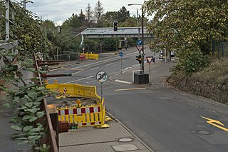
View from the staircase of the Anger-Crottendorf halt to Zweinaundorfer Straße
Summary edit
| Description |
Deutsch: Der bestehende Bahndamm des Leipziger Güterrings wurde am Haltepunkt Anger-Crottendorf für die Dauer der Baumaßnahmen mit Spundwänden verstärkt. Der Fußweg unter der Eisenbahnüberführung Zweinaundorfer Straße sowie Teile der Widerlager sind bereits ausgebaut. Eine Baustellenampel regelt den einspurigen Straßenverkehr im Brückenbereich der Kreuzung Zweinaundorfer Straße / Am Güterring. In der Folge werden in leicht veränderter Lage zwei Brücken sowie ein neuer Bahndamm samt Gleisen errichtet.
English: The existing railway embankment of the Leipziger Güterring was reinforced with sheet metal walls at the Anger-Crottendorf stop for the duration of the construction work. The footpath under the Zweinaundorfer Straße railway overpass as well as parts of the abutments have already been expanded. A construction site light regulates single-lane road traffic in the bridge area at the Zweinaundorfer Straße / Am Güterring junction. As a result, two bridges and a new railway embankment including tracks will be erected in a slightly changed position..
Français : Le barrage ferroviaire existant de l'anneau de marchandises de Leipzig a été renforcé à l'arrêt Anger-Crottendorf pour la durée des travaux de construction. Le trottoir sous la voie ferrée Zweinaundorfer Straße ainsi que certaines parties des contreforts ont déjà été aménagés. Un feu de chantier régule le trafic routier à voie unique dans la zone de pont de la jonction Zweinaundorfer Straße / Am Güterring. Par la suite, deux ponts seront construits dans une position légèrement modifiée, ainsi qu'un nouveau barrage ferroviaire et des voies ferrées.
Español: La presa ferroviaria existente del anillo de Leipziger Güterring se reforzó en la parada de Anger-Crottendorf con muros de contención durante el período de construcción. El camino peatonal por debajo del cruce ferroviario Zweinaundorfer Straße, así como partes de los campos de concentración ya se han ampliado. Un semáforo de obra regula el tráfico de una sola vía en la zona del puente de la intersección Zweinaundorfer Straße / Am Güterring. A continuación se construirán dos puentes y una nueva presa ferroviaria con vías en una posición ligeramente modificada.
Čeština: Stávající železniční násep na Leipziger Güterring byl po dobu stavebních prací zpevněn štětovnicí ve stanici Anger-Crottendorf. Stezka pod železničním nadjezdem Zweinaundorfer Straße a části opěr již byly vyvinuty. Semafor na staveništi reguluje jednopruhovou silniční dopravu v oblasti mostu křižovatky Zweinaundorfer Straße / Am Güterring. V důsledku toho budou postaveny dva mosty a nový železniční násep včetně kolejí v trochu jiné lokalitě. |
||||||
| Aufnahme | This photograph was taken with a Nikon D750 |
||||||
| Date | |||||||
| Source | Own work | ||||||
| Author | August Geyler | ||||||
| Permission (Reusing this file) |
|
||||||
| Attribution (required by the license) | © August Geyler / Wikimedia Commons / | ||||||


| Camera location | | View this and other nearby images on: OpenStreetMap |
|---|
Licensing edit
I, the copyright holder of this work, hereby publish it under the following license:
This file is licensed under the Creative Commons Attribution-Share Alike 4.0 International license.
- You are free:
- to share – to copy, distribute and transmit the work
- to remix – to adapt the work
- Under the following conditions:
- attribution – You must give appropriate credit, provide a link to the license, and indicate if changes were made. You may do so in any reasonable manner, but not in any way that suggests the licensor endorses you or your use.
- share alike – If you remix, transform, or build upon the material, you must distribute your contributions under the same or compatible license as the original.
File history
Click on a date/time to view the file as it appeared at that time.
| Date/Time | Thumbnail | Dimensions | User | Comment | |
|---|---|---|---|---|---|
| current | 19:41, 27 September 2020 | | 5,825 × 3,878 (20.12 MB) | Augustgeyler (talk | contribs) | Uploaded own work with UploadWizard |
You cannot overwrite this file.
File usage on Commons
The following 6 pages use this file:
- User:Clic/Nahverkehr in Deutschland/2020 September 21-30
- User:J budissin/Uploads/BZ/2020 September 21-30
- User:Nordlicht8/Rail Germany/2020 September 21-30
- User:Roy17/Leipzig/2020 September
- Commons:Quality images candidates/Archives March 31 2023
- File:Baustelle am Haltepunkt Leipzig-Anger-Crottendorf-3.jpg