File:Bayern, Uraufnahme (1808-1864), Toteisverlandung Schwarzelmoos nördlich Chieming.jpg

Size of this preview: 545 × 599 pixels. Other resolutions: 218 × 240 pixels | 437 × 480 pixels | 746 × 820 pixels.
Original file (746 × 820 pixels, file size: 297 KB, MIME type: image/jpeg)
Captions
Captions
Add a one-line explanation of what this file represents
Summary edit
,_Toteisverlandung_Schwarzelmoos_n%C3%B6rdlich_Chieming.jpg&action=edit§ion=1)
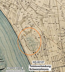
| Description | Bayern, Uraufnahme (1808-1864), Toteisverlandungen Schwarzelmoos, Gemeinde Chieming |
| Source | Bayern, Uraufnahme (1808-1864) |
| Author | Königreich Bayern |
| Permission (Reusing this file) |
gemeinfrei |
In der Zeichung sind deutlich die umrandenden Böschungswinkel zu erkennen. Die blaue Schraffierung markiert den moorigen Untergrund.
| Camera location | | View this and other nearby images on: OpenStreetMap |
|---|
,_Toteisverlandung_Schwarzelmoos_n%C3%B6rdlich_Chieming.jpg¶ms=047.895970_N_0012.529550_E_globe:Earth_type:camera_region:DE-BY_scale:10000_&language=en)
|
This work is in the public domain in its country of origin and other countries and areas where the copyright term is the author's life plus 100 years or fewer. | |
| This file has been identified as being free of known restrictions under copyright law, including all related and neighboring rights. | |
File history
Click on a date/time to view the file as it appeared at that time.
| Date/Time | Thumbnail | Dimensions | User | Comment | |
|---|---|---|---|---|---|
| current | 05:49, 7 February 2024 | | 746 × 820 (297 KB) | Perchtinger (talk | contribs) | {{Information |Description=Bayern, Uraufnahme (1808-1864), Toteisverlandungen Schwarzelmoos, Gemeinde Chieming |Source=Bayern, Uraufnahme (1808-1864) |Date= |Author= Königreich Bayern |Permission=gemeinfrei |other_versions= }} In der Zeichung sind deutlich die umrandenden Böschungswinkel zu erkennen. Die blaue Schraffierung markiert den moorigen Untergrund. {{Location dec|47.89597|12.52955|region:DE-BY_scale:10000_heading:O}} {{PD-old-100}} Category:Chieming [[Category:Maps from BayernA... |
You cannot overwrite this file.
File usage on Commons
There are no pages that use this file.
File usage on other wikis
The following other wikis use this file:
- Usage on de.wikipedia.org
,_Toteisverlandung_Schwarzelmoos_nördlich_Chieming.jpg&oldid=855288941)