File:BayreuthMap.svg

Size of this PNG preview of this SVG file: 800 × 567 pixels. Other resolutions: 320 × 227 pixels | 640 × 454 pixels | 1,024 × 726 pixels | 1,280 × 908 pixels | 2,560 × 1,815 pixels | 1,715 × 1,216 pixels.
Original file (SVG file, nominally 1,715 × 1,216 pixels, file size: 244 KB)
Captions
Captions
Add a one-line explanation of what this file represents
Summary edit
| Description |
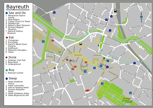
English: Map of Bayreuth, Germany's city center. A quick map detailing the city center of Bayreuth, Germany, and also listing some attractions, restaurants, hotels, and bars., Bayreuth
|
| Date | |
| Source | Own work, generated from OpenStreetMap data |
| Author | HokiesVT |
| This work contains information from OpenStreetMap, which is made available under the Open Database License (ODbL).
The ODbL does not require any particular license for maps produced from ODbL data. Prior to 1 August 2020, map tiles produced by the OpenStreetMap Foundation were licensed under the CC-BY-SA-2.0 license. Maps produced by other people may be subject to other licences. |
This W3C-unspecified vector image was created with Inkscape .
Licensing edit
This file is licensed under the Creative Commons Attribution-Share Alike 4.0 International, 3.0 Unported, 2.5 Generic, 2.0 Generic and 1.0 Generic license.
- You are free:
- to share – to copy, distribute and transmit the work
- to remix – to adapt the work
- Under the following conditions:
- attribution – You must give appropriate credit, provide a link to the license, and indicate if changes were made. You may do so in any reasonable manner, but not in any way that suggests the licensor endorses you or your use.
- share alike – If you remix, transform, or build upon the material, you must distribute your contributions under the same or compatible license as the original.
Original upload log edit
| This file was imported from Wikivoyage WTS. |
The original description page was here. All following user names refer to wts.wikivoyage-old.
- 2009-03-12 23:43 (WT-shared) Hokiesvt[dead link] 744×1052 (455357 bytes) {{Imagecredit|credit=HokiesVT|captureDate=March 12, 2009|location=|source=BayreuthMap.svg|caption=Map of Bayreuth, Germany's city center|des (Import from wikitravel.org/shared)
- 2012-09-13 01:45 LtPowers[dead link] 1499×1198 (410906 bytes) Remove old logo; resize map elements for readability
- 2012-09-13 11:42 ImportBot[dead link] 1499×1198 (408240 bytes) rm WT-logo
File history
Click on a date/time to view the file as it appeared at that time.
| Date/Time | Thumbnail | Dimensions | User | Comment | |
|---|---|---|---|---|---|
| current | 10:53, 21 November 2015 | | 1,715 × 1,216 (244 KB) | Hdamm (talk | contribs) | fixed fonts in legend, clean up |
| 05:38, 21 November 2012 |  | 1,499 × 1,198 (399 KB) | OgreBot (talk | contribs) | (BOT): Reverting to most recent version before archival | |
| 05:37, 21 November 2012 |  | 1,499 × 1,198 (401 KB) | OgreBot (talk | contribs) | (BOT): Uploading old version of file from wts.wikivoyage; originally uploaded on 2012-09-13 01:45:40 by LtPowers | |
| 05:37, 21 November 2012 |  | 744 × 1,052 (445 KB) | OgreBot (talk | contribs) | (BOT): Uploading old version of file from wts.wikivoyage; originally uploaded on 2009-03-12 23:43:16 by (WT-shared) Hokiesvt | |
| 22:41, 17 November 2012 |  | 1,499 × 1,198 (399 KB) | MGA73bot2 (talk | contribs) | {{BotMoveToCommons|wts.oldwikivoyage|year={{subst:CURRENTYEAR}}|month={{subst:CURRENTMONTHNAME}}|day={{subst:CURRENTDAY}}}} == {{int:filedesc}} == {{Information |description=Map of Bayreuth, Germany's city center. A quick map detailing the city center ... |
You cannot overwrite this file.
File usage on Commons
The following 2 pages use this file:
File usage on other wikis
The following other wikis use this file:
- Usage on ko.wikipedia.org