File:Bd Saint-Martin2.jpg

Original file (3,312 × 4,416 pixels, file size: 2.36 MB, MIME type: image/jpeg)
Captions
Captions
Summary edit
| DescriptionBd Saint-Martin2.jpg |
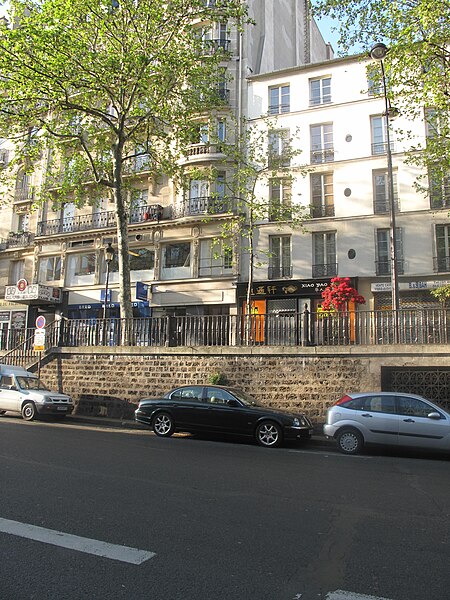
English: The Boulevard Saint-Martin, Paris 3rd arr. Created at the foot and in place of the wall of Charles V, the pavement has been digged to make easier transits of horses cars without hard climb or descent. But the sidewalks stay higher.
Français : Le Boulevard Saint-Martin, Paris 3e arr. Tracé au pied et à la place de l'enceinte de Charles V, la chaussée a été abaissée pour faciliter le passage des carrosses et voitures à chevaux en évitant une montée et une descente de pente trop forte. Mais les trottoirs sont restés plus élevés. |
| Date | |
| Source | Own work |
| Author | Tangopaso |
| Other versions |
 |
| Camera location | 48° 52′ 07.53″ N, 2° 21′ 26.43″ E | View this and other nearby images on: OpenStreetMap |
|---|
Licensing edit
| Public domainPublic domainfalsefalse |
| |
This work has been released into the public domain by its author, Tangopaso, at the [[::|English Wikipedia]] project. This applies worldwide. In case this is not legally possible: |
File history
Click on a date/time to view the file as it appeared at that time.
| Date/Time | Thumbnail | Dimensions | User | Comment | |
|---|---|---|---|---|---|
| current | 21:28, 5 May 2010 |  | 3,312 × 4,416 (2.36 MB) | Tangopaso (talk | contribs) | == {{int:filedesc}} == {{Information |Description={{en|1=The Boulevard Saint-Martin, Paris 3rd arr. Created at the foot and in place of the wall of Charles V, the pavement has been digged to make easier transits of horses cars without hard climb or descen |
You cannot overwrite this file.
File usage on Commons
The following 2 pages use this file:
Metadata
This file contains additional information such as Exif metadata which may have been added by the digital camera, scanner, or software program used to create or digitize it. If the file has been modified from its original state, some details such as the timestamp may not fully reflect those of the original file. The timestamp is only as accurate as the clock in the camera, and it may be completely wrong.
| Camera manufacturer | Canon |
|---|---|
| Camera model | Canon PowerShot G10 |
| Exposure time | 1/100 sec (0.01) |
| F-number | f/4 |
| ISO speed rating | 80 |
| Date and time of data generation | 08:14, 27 April 2010 |
| Lens focal length | 6.1 mm |
| Orientation | Normal |
| Horizontal resolution | 180 dpi |
| Vertical resolution | 180 dpi |
| Software used | Microsoft Windows Photo Gallery 6.0.6001.18000 |
| File change date and time | 22:03, 28 April 2010 |
| Y and C positioning | Co-sited |
| Exif version | 2.21 |
| Date and time of digitizing | 08:14, 27 April 2010 |
| Image compression mode | 2 |
| APEX shutter speed | 6.65625 |
| APEX aperture | 4 |
| APEX exposure bias | 0 |
| Maximum land aperture | 2.96875 APEX (f/2.8) |
| Metering mode | Pattern |
| Flash | Flash did not fire, auto mode |
| Color space | sRGB |
| Focal plane X resolution | 15,123.287671233 |
| Focal plane Y resolution | 15,123.287671233 |
| Focal plane resolution unit | inches |
| Sensing method | One-chip color area sensor |
| Custom image processing | Normal process |
| Exposure mode | Auto exposure |
| White balance | Auto white balance |
| Digital zoom ratio | 1 |
| Scene capture type | Standard |