File:Beaufort District, South Carolina LOC 2012590212.jpg

Size of this preview: 481 × 600 pixels. Other resolutions: 192 × 240 pixels | 385 × 480 pixels | 616 × 768 pixels | 821 × 1,024 pixels | 1,642 × 2,048 pixels | 7,961 × 9,927 pixels.
Original file (7,961 × 9,927 pixels, file size: 10.63 MB, MIME type: image/jpeg)
Captions
Captions
Add a one-line explanation of what this file represents
Summary edit
| Warning | The original file is very high-resolution. It might not load properly or could cause your browser to freeze when opened at full size. |
|---|
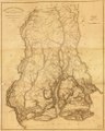
| Description |
English: Shows land ownership. "Improved for Mills' Atlas, 1825." LC copy annotated in lower right corner, accompanied by photocopy, and mounted on cloth. Available also through the Library of Congress Web site as a raster image. |
||
| Title | Beaufort District, South Carolina | ||
| Shelf ID | G3913.B4 1820 .B4 | ||
| Date | |||
| Source | https://www.loc.gov/item/2012590212/ | ||
| Author | Mills, Robert; Vignoles, Charles Blacker; Tanner, Henry Schenck; Ravenel, Henry | ||
| Permission (Reusing this file) |
|
||
| Other versions |
|
||
| Location | South Carolina · United States · Beaufort County | ||
| Part of | American Memory · Catalog · Geography And Map Division · Cultural Landscapes | ||
| Subject | Cadastral Maps · Beaufort County · United States · Maps · South Carolina · Real Property · Landowners · Beaufort County (S.C.) |

Licensing edit
|
This is a faithful photographic reproduction of a two-dimensional, public domain work of art. The work of art itself is in the public domain for the following reason:
The official position taken by the Wikimedia Foundation is that "faithful reproductions of two-dimensional public domain works of art are public domain".
This photographic reproduction is therefore also considered to be in the public domain in the United States. In other jurisdictions, re-use of this content may be restricted; see Reuse of PD-Art photographs for details. | ||||
File history
Click on a date/time to view the file as it appeared at that time.
| Date/Time | Thumbnail | Dimensions | User | Comment | |
|---|---|---|---|---|---|
| current | 20:45, 15 June 2018 | | 7,961 × 9,927 (10.63 MB) | Fæ (talk | contribs) | LOC Maps https://www.loc.gov/item/2012590212/ #16661 |
You cannot overwrite this file.
File usage on Commons
The following page uses this file: