File:Beijing (40298461021).jpg

Original file (4,885 × 4,201 pixels, file size: 5.5 MB, MIME type: image/jpeg)
Captions
Captions
Summary edit
.jpg&action=edit§ion=1)
| Description |
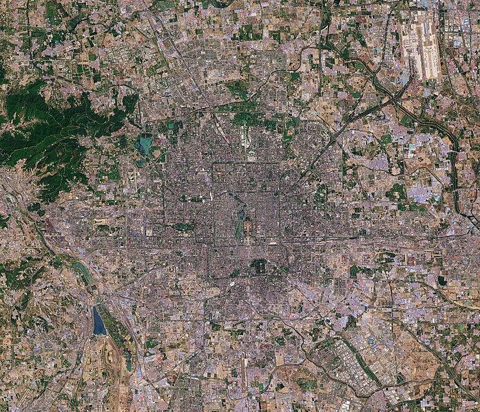
Today, 16 February, upwards of 20% of the world’s population will be celebrating Chinese New Year, also known as the Spring Festival. According to the traditional Chinese calendar, which is based on the lunar cycle and the position of the Sun, the New Year changes each year, but always falls between 21 January and 20 February. There are 12 Chinese zodiac animals that represent years, and 2018 is the year of the dog. Marking this special day, we take a look at a Sentinel-2 image of Beijing, the capital of China. It is one of the most populous cities in the world, with over 21 million people, but during the New Year millions travel from the big cities back to their hometowns to spend the holiday with their families in what is considered the world’s largest annual migration. Beijing lies in northeast China at the northern tip of the North China Plain. While the city lies on flat ground, it is surrounded by mountains to the north and west (not pictured). From space, the city appears to be divided up into many squares, which is a consequence of it being one of oldest planned cities in the world. Beijing’s present urban form was established in the early Ming dynasty – between 1368 and 1644 – with planning stipulating that the city should be a square encompassing nine avenues running north–south and nine running east–west. While this Copernicus Sentinel-2 image details much of the city, a number of famous landmarks can be picked out easily. For example, lying in the heart of Beijing, the Forbidden City, one of China’s largest and best preserved heritage sites, and Tiananmen Square can be seen. Happy Chinese Year – or Xīn nián kuài lè – to all. This Sentinel-2 image, which was captured on 3 May 2016, is also featured on the <a href="http://www.esa.int/spaceinvideos/Videos/2018/02/Earth_from_Space_Beijing/" rel="noreferrer nofollow">Earth from Space video programme</a>. Credits: contains modified Copernicus Sentinel data (2016), processed by ESA, <a href="https://creativecommons.org/licenses/by-sa/3.0/igo/" rel="noreferrer nofollow">CC BY-SA 3.0 IGO</a> |
|||||||||
| Date | ||||||||||
| Source | Beijing | |||||||||
| Creator | ||||||||||
| Geotemporal data | ||||||||||
| Bounding box |
|
|||||||||
| Georeferencing | ||||||||||
| Camera location | | View this and other nearby images on: OpenStreetMap |
|---|
.jpg¶ms=039.918952_N_0116.388816_E_globe:Earth_type:camera_source:Flickr_&language=en)
Licensing edit
.jpg&action=edit§ion=2)
- You are free:
- to share – to copy, distribute and transmit the work
- to remix – to adapt the work
- Under the following conditions:
- attribution – You must give appropriate credit, provide a link to the license, and indicate if changes were made. You may do so in any reasonable manner, but not in any way that suggests the licensor endorses you or your use.
- share alike – If you remix, transform, or build upon the material, you must distribute your contributions under the same or compatible license as the original.
| This image was originally posted to Flickr by europeanspaceagency at https://flickr.com/photos/37472264@N04/40298461021 (archive). It was reviewed on 2 March 2020 by FlickreviewR 2 and was confirmed to be licensed under the terms of the cc-by-sa-2.0. |
File history
Click on a date/time to view the file as it appeared at that time.
| Date/Time | Thumbnail | Dimensions | User | Comment | |
|---|---|---|---|---|---|
| current | 02:02, 2 March 2020 | | 4,885 × 4,201 (5.5 MB) | Up and Go (talk | contribs) | Transferred from Flickr via #flickr2commons |
You cannot overwrite this file.
File usage on Commons
More than 100 pages use this file. The following list shows the first 100 pages that use this file only. A full list is available.
.jpg)
- 北京
- Commons:WikiProject Aviation/recent uploads/2020 March 2
- Category:1949 in Beijing
- Category:1950 in Beijing
- Category:1954 in Beijing
- Category:1955 in Beijing
- Category:1956 in Beijing
- Category:1957 in Beijing
- Category:1959 in Beijing
- Category:1963 in Beijing
- Category:1964 in Beijing
- Category:1965 in Beijing
- Category:1966 in Beijing
- Category:1967 in Beijing
- Category:1968 in Beijing
- Category:1972 in Beijing
- Category:1976 in Beijing
- Category:1978 in Beijing
- Category:1980 in Beijing
- Category:1981 in Beijing
- Category:1982 in Beijing
- Category:1983 in Beijing
- Category:1984 in Beijing
- Category:1985 in Beijing
- Category:1986 in Beijing
- Category:1987 in Beijing
- Category:1988 in Beijing
- Category:1989 in Beijing
- Category:1990 in Beijing
- Category:1993 in Beijing
- Category:1994 in Beijing
- Category:1997 in Beijing
- Category:1998 in Beijing
- Category:1999 in Beijing
- Category:2000 in Beijing
- Category:2001 in Beijing
- Category:2002 in Beijing
- Category:2003 in Beijing
- Category:2004 in Beijing
- Category:2005 in Beijing
- Category:2006 in Beijing
- Category:2007 in Beijing
- Category:2008 in Beijing
- Category:2009 in Beijing
- Category:2010 in Beijing
- Category:2011 in Beijing
- Category:2012 in Beijing
- Category:2013 in Beijing
- Category:2014 in Beijing
- Category:2015 in Beijing
- Category:2016 in Beijing
- Category:2017 in Beijing
- Category:2018 in Beijing
- Category:2019 in Beijing
- Category:2020 in Beijing
- Category:2021 in Beijing
- Category:2022 in Beijing
- Category:Airports in Beijing
- Category:Alumni by university or college in Beijing
- Category:Architecture of Beijing
- Category:Beijing
- Category:Beijing in the 18th century
- Category:Beijing in the 1960s
- Category:Beijing in the 1970s
- Category:Beijing in the 1980s
- Category:Beijing in the 1990s
- Category:Beijing in the 19th century
- Category:Beijing in the 2000s
- Category:Beijing in the 2010s
- Category:Beijing in the 2020s
- Category:Beijing in the 20th century
- Category:Beijing in the 21st century
- Category:Births in Beijing
- Category:Bridges in Beijing
- Category:Buddhism in Beijing
- Category:Buildings in Beijing
- Category:Churches in Beijing
- Category:Companies of Beijing
- Category:Deaths in Beijing
- Category:Districts of Beijing
- Category:Events in Beijing
- Category:Gardens and parks in Beijing
- Category:Hospitals in Beijing
- Category:Houses in Beijing
- Category:Hutong in Beijing
- Category:Islam in Beijing
- Category:Lakes of Beijing
- Category:Maps of Beijing
- Category:Monuments and memorials in Beijing
- Category:Mosques in Beijing
- Category:Mountains of Beijing
- Category:Orthodox churches in Beijing
- Category:Rail transport in Beijing
- Category:Rivers of Beijing
- Category:Sports in Beijing
- Category:Sports venues in Beijing
- Category:Streets in Beijing
- Category:Train stations in Beijing
- Category:Transport buildings in Beijing
- Category:Universities and colleges in Beijing
View more links to this file.
File usage on other wikis
The following other wikis use this file:
.jpg&oldid=820274114)