File:Berlin - Lage der geplanten Ost-West-S-Bahn (Karte).png

Size of this preview: 800 × 584 pixels. Other resolutions: 320 × 234 pixels | 640 × 468 pixels | 1,024 × 748 pixels | 1,280 × 935 pixels | 2,282 × 1,667 pixels.
Original file (2,282 × 1,667 pixels, file size: 1.49 MB, MIME type: image/png)
Captions
Captions
Add a one-line explanation of what this file represents
| Description |
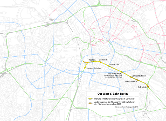
Deutsch: Lage der ehemals geplanten Ost-West-S-Bahn im heutigen Verkehrsnetz von Berlin
English: Situation of the former planned Ost-West-S-Bahn in the current Berlin transportation network
This map of Berlin was created from OpenStreetMap project data, collected by the community.This map may be incomplete, and may contain errors. Don't rely solely on it for navigation. |
| Date | see file history |
| Source | OpenStreetMap data exported an adapted by myself |
| Creator |
OpenStreetMap contributors |
| Permission (Reusing this file) |
All OpenStreetMap data and maps are Creative Commons "CC-BY-SA 2.0" licensed This file is licensed under the Creative Commons Attribution-Share Alike 2.0 Generic license.
|
| Georeferencing | If inappropriate please set warp_status = skip to hide. |
| Other versions |
=
|
.png)
.png)
.png)

|
This transport map image could be re-created using vector graphics as an SVG file. This has several advantages; see Commons:Media for cleanup for more information. If an SVG form of this image is available, please upload it and afterwards replace this template with
{{vector version available|new image name}}.
It is recommended to name the SVG file “Berlin - Lage der geplanten Ost-West-S-Bahn (Karte).svg”—then the template Vector version available (or Vva) does not need the new image name parameter. |
File history
Click on a date/time to view the file as it appeared at that time.
| Date/Time | Thumbnail | Dimensions | User | Comment | |
|---|---|---|---|---|---|
| current | 19:45, 7 February 2017 | | 2,282 × 1,667 (1.49 MB) | Chumwa (talk | contribs) | corr |
| 21:59, 6 February 2017 |  | 2,282 × 1,667 (1.49 MB) | Chumwa (talk | contribs) | corr | |
| 08:40, 6 August 2012 |  | 1,522 × 1,111 (541 KB) | Kopiersperre (talk | contribs) | optipng | |
| 13:11, 21 June 2009 |  | 1,522 × 1,111 (821 KB) | Chumwa (talk | contribs) | Typo | |
| 20:55, 19 June 2009 |  | 1,522 × 1,111 (821 KB) | Chumwa (talk | contribs) | Unterscheidung zwischen den Planungen 1937/38 und 1965 durchgeführt | |
| 15:34, 19 June 2009 |  | 1,522 × 1,111 (822 KB) | Chumwa (talk | contribs) | {{Information |Description={{de|Lage der geplanten Ost-West-S-Bahn im heutigen Verkehrsnetz von Berlin}} {{en|Situation of the planned Ost-West-S-Bahn in the current Berlin transportation network}} This map of Berlin was created from OpenStreetMap pr |
You cannot overwrite this file.
File usage on Commons
The following 8 pages use this file:
- User:Chumwa/Gallery
- User:Chumwa/OgreBot/Potential transport maps/2017 February 1-9
- User:Chumwa/OgreBot/Public transport information/2017 February 1-9
- User:Chumwa/OgreBot/Transport Maps/2017 February 1-9
- User:Chumwa/OgreBot/Travel and communication maps/2017 February 1-9
- File:Berlin - Lage der geplanten Ost-West-S-Bahn (Karte).png
- File:Berlin - Lage der geplanten Ost-West-S-Bahn (Karte mit Planungsstand 1937-1938).png
- File:Berlin - Lage der geplanten Ost-West-S-Bahn (Karte mit Planungsstand 1965).png
File usage on other wikis
The following other wikis use this file:
- Usage on de.wikipedia.org
- Usage on www.wikidata.org
.png&oldid=821783080)