File:Bernsteinstraße-Radweg - Raiding.jpg

Size of this preview: 800 × 350 pixels. Other resolutions: 320 × 140 pixels | 640 × 280 pixels | 1,024 × 447 pixels | 1,280 × 559 pixels | 2,560 × 1,119 pixels | 5,795 × 2,532 pixels.
Original file (5,795 × 2,532 pixels, file size: 3.04 MB, MIME type: image/jpeg)
Captions
Captions
Add a one-line explanation of what this file represents
Summary edit
| Object location | | View this and other nearby images on: OpenStreetMap |
|---|
| Description |
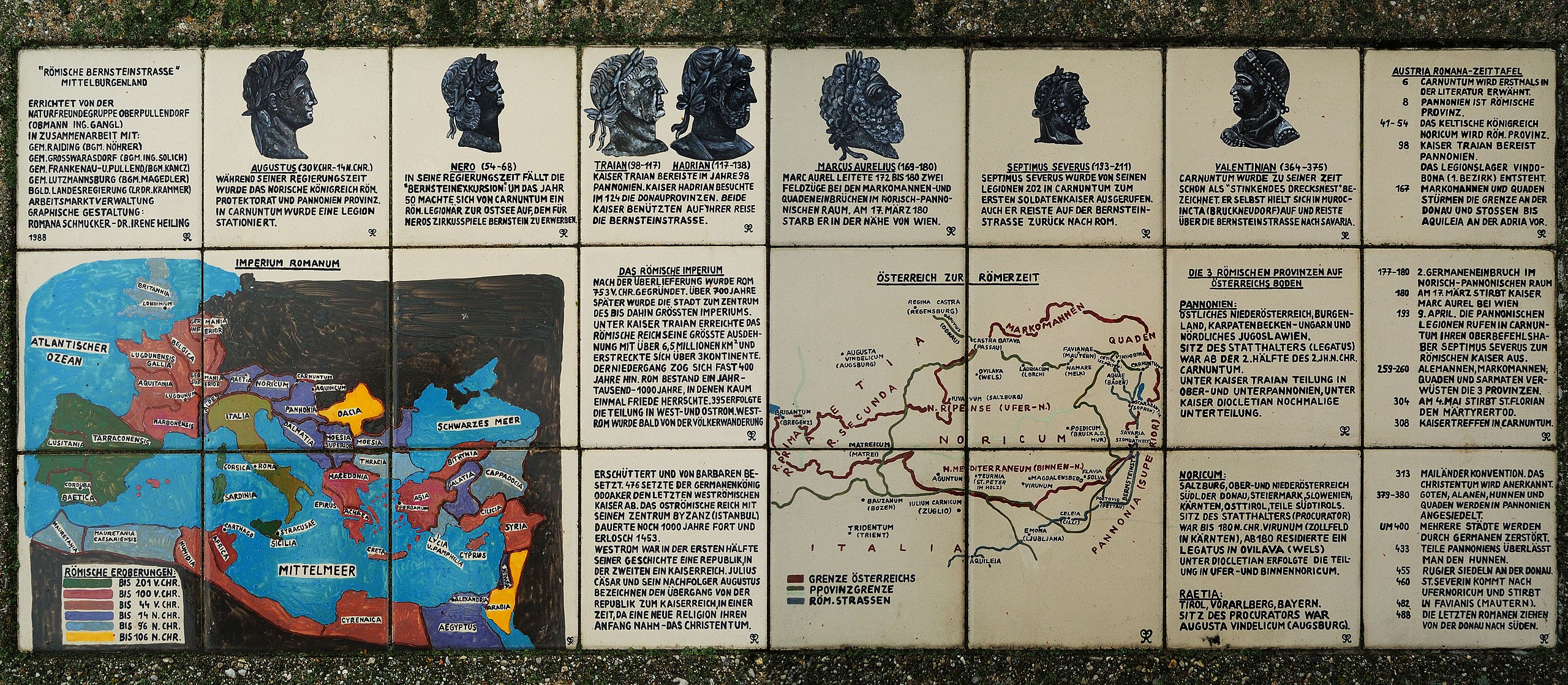
Deutsch: Schautafel zum Bernsteinstraße-Radweg bei Raiding, Burgenland, Österreich
English: Presentation board for the amberstreet-bicycle route near Raiding, Burgenland, Austria |
| Date | |
| Source | Own work |
| Author | Robert Heilinger |
| Camera location | | View this and other nearby images on: OpenStreetMap |
|---|
Licensing edit
I, the copyright holder of this work, hereby publish it under the following license:
This file is licensed under the Creative Commons Attribution-Share Alike 3.0 Unported license.
- You are free:
- to share – to copy, distribute and transmit the work
- to remix – to adapt the work
- Under the following conditions:
- attribution – You must give appropriate credit, provide a link to the license, and indicate if changes were made. You may do so in any reasonable manner, but not in any way that suggests the licensor endorses you or your use.
- share alike – If you remix, transform, or build upon the material, you must distribute your contributions under the same or compatible license as the original.
File history
Click on a date/time to view the file as it appeared at that time.
| Date/Time | Thumbnail | Dimensions | User | Comment | |
|---|---|---|---|---|---|
| current | 15:29, 28 December 2012 | | 5,795 × 2,532 (3.04 MB) | Robert Heilinger (talk | contribs) | =={{int:filedesc}}== {{Object location dec|47.56016|16.52589|region:AT-1}} {{Information |description= {{de|1=Schautafel zum Bernsteinstraße-Radweg bei Raiding, Burgenland, Österreich}} {{en|1=Presentation board for the amberstreet-bicycle route near... |
You cannot overwrite this file.
File usage on Commons
There are no pages that use this file.