File:Black Hill (Holme Moss) Ordnance Survey Triangulation Pillar - geograph.org.uk - 521090.jpg
No higher resolution available.
Black_Hill_(Holme_Moss)_Ordnance_Survey_Triangulation_Pillar_-_geograph.org.uk_-_521090.jpg (640 × 364 pixels, file size: 50 KB, MIME type: image/jpeg)
Captions
Captions
Add a one-line explanation of what this file represents
Summary edit
_Ordnance_Survey_Triangulation_Pillar_-_geograph.org.uk_-_521090.jpg&action=edit§ion=1)
| Description |
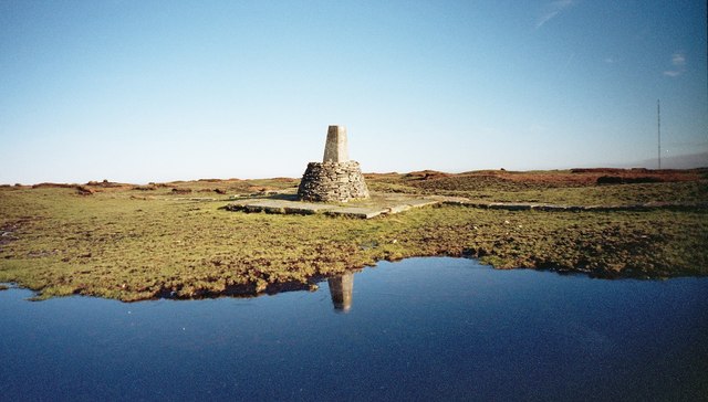
English: Black Hill (Holme Moss) Ordnance Survey Triangulation Pillar At 582 metres (1,908 feet) above sea-level, Black Hill (Holme Moss) was once "the highest hill in old Cheshire" before local government re-organisation in 1974. On the OS map, the locality is alternatively known as "Soldiers Lump", this being a reference to the 18th century visits of the Royal Engineer surveyors who first used it as a surveying point.
Nowadays the concrete Ordnance Survey triangulation pillar at Black Hill summit (Flush Bracket number 2958 - the absence of the S prefix denotes that this is a primary pillar) languishes in the middle of an all-enveloping quagmire of wet, knee-deep goo. You can see how much the peat has eroded over the years as the base of the pillar, constructed in 1936, is now a few feet above ground level. Before the paving slabs were laid, after a period of heavy rain, the pillar used to be virtually unapproachable, but a very welcome sight in thick moorland clag. |
| Date | |
| Source | From geograph.org.uk |
| Author | Manchester Warrior |
| Attribution (required by the license) | Manchester Warrior / Black Hill (Holme Moss) Ordnance Survey Triangulation Pillar / |
| Camera location | | View this and other nearby images on: OpenStreetMap |
|---|
_Ordnance_Survey_Triangulation_Pillar_-_geograph.org.uk_-_521090.jpg¶ms=053.538698_N_-001.883660_E_globe:Earth_type:camera_source:geograph-osgb36(SE0780704678)_heading:90.00&language=en)
| Object location | | View this and other nearby images on: OpenStreetMap |
|---|
_Ordnance_Survey_Triangulation_Pillar_-_geograph.org.uk_-_521090.jpg¶ms=053.538698_N_-001.883660_E_globe:Earth_class:object_type:object_source:geograph-osgb36(SE0780704678)_heading:90.00&language=en)
Licensing edit
_Ordnance_Survey_Triangulation_Pillar_-_geograph.org.uk_-_521090.jpg&action=edit§ion=2)

|
This image was taken from the Geograph project collection. See this photograph's page on the Geograph website for the photographer's contact details. The copyright on this image is owned by Manchester Warrior and is licensed for reuse under the Creative Commons Attribution-ShareAlike 2.0 license.
|
This file is licensed under the Creative Commons Attribution-Share Alike 2.0 Generic license.
Attribution: Manchester Warrior
- You are free:
- to share – to copy, distribute and transmit the work
- to remix – to adapt the work
- Under the following conditions:
- attribution – You must give appropriate credit, provide a link to the license, and indicate if changes were made. You may do so in any reasonable manner, but not in any way that suggests the licensor endorses you or your use.
- share alike – If you remix, transform, or build upon the material, you must distribute your contributions under the same or compatible license as the original.
_Ordnance_Survey_Triangulation_Pillar_-_geograph.org.uk_-_521090.jpg&action=edit&withJS=MediaWiki:Catcheck.js)
- Remove redundant categories and try to put this image in the most specific category/categories
- Remove this template
- The location categories are based on information from this geonames tool and this OpenStreetMap tool combined with a database. You can also have a look at this tool from mysociety.
- The topic category from Geograph was Triangulation Pillar (find similar images Pillar at Geograph)
File history
Click on a date/time to view the file as it appeared at that time.
| Date/Time | Thumbnail | Dimensions | User | Comment | |
|---|---|---|---|---|---|
| current | 15:35, 5 February 2011 | | 640 × 364 (50 KB) | GeographBot (talk | contribs) | == {{int:filedesc}} == {{Information |description={{en|1=Black Hill (Holme Moss) Ordnance Survey Triangulation Pillar At 582 metres (1,908 feet) above sea-level, Black Hill (Holme Moss) was once "the highest hill in old Cheshire" before local government r |
You cannot overwrite this file.
File usage on Commons
There are no pages that use this file.
File usage on other wikis
The following other wikis use this file:
- Usage on fr.wikipedia.org
_Ordnance_Survey_Triangulation_Pillar_-_geograph.org.uk_-_521090.jpg&oldid=825096871)