File:Black bear map.png
No higher resolution available.
Black_bear_map.png (515 × 599 pixels, file size: 77 KB, MIME type: image/png)
Captions
Captions
Add a one-line explanation of what this file represents
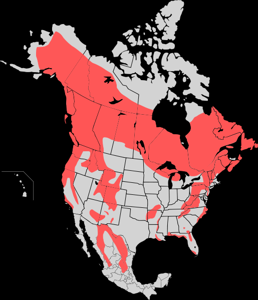
| Description | Range map of the American Black Bear (Ursus Americanus) updated, see: http://blogs.courierpostonline.com/fishhead/files/2008/12/beardist.jpg http://www.nps.gov/shen/naturescience/images/va_dgif_bear_map_556.jpg http://www.dec.ny.gov/images/wildlife_images/bearngexp9507.jpg http://www.ncwildlife.org/Wildlife_Species_Con/images/bear_dist_map.pdf |
| Date | (UTC) |
| Source | |
| Author |
|
| Other versions | Derivative works of this file: American Black bear map.png |
| This is a retouched picture, which means that it has been digitally altered from its original version. Modifications: expanded range due to more recent data http://blogs.courierpostonline.com/fishhead/files/2008/12/beardist.jpg http://www.nps.gov/shen/naturescience/images/va_dgif_bear_map_556.jpg http://www.dec.ny.gov/images/wildlife_images/bearngexp9507.jpg http://www.ncwildlife.org/Wildlife_Species_Con/images/bear_dist_map.pdf http://www.dnr.state.md.us/wildlife/gpar/art/bb_fig1.jpg. The original can be viewed here: Map Black Bear.svg:
|
I, the copyright holder of this work, hereby publish it under the following license:
This file is licensed under the Creative Commons Attribution-Share Alike 3.0 Unported license.
- You are free:
- to share – to copy, distribute and transmit the work
- to remix – to adapt the work
- Under the following conditions:
- attribution – You must give appropriate credit, provide a link to the license, and indicate if changes were made. You may do so in any reasonable manner, but not in any way that suggests the licensor endorses you or your use.
- share alike – If you remix, transform, or build upon the material, you must distribute your contributions under the same or compatible license as the original.
Original upload log edit
This image is a derivative work of the following images:
- File:Map_Black_Bear.svg licensed with Cc-by-sa-3.0
- 2010-01-20T20:47:11Z Kmusser 1712x1992 (445308 Bytes) {{Information |Description=Range map of the American Black Bear (Ursus Americanus) |Source={{own}}, [[:File:North America second level political division 2.svg]] used as basemap. Range distribution from the North American Bea
Uploaded with derivativeFX
File history
Click on a date/time to view the file as it appeared at that time.
| Date/Time | Thumbnail | Dimensions | User | Comment | |
|---|---|---|---|---|---|
| current | 18:58, 9 March 2010 | | 515 × 599 (77 KB) | Bobisbob~commonswiki (talk | contribs) | {{Information |Description=Range map of the American Black Bear (Ursus Americanus) |Source=*File:Map_Black_Bear.svg |Date=2010-03-09 18:56 (UTC) |Author=*File:Map_Black_Bear.svg: Kmusser *derivative work: ~~~ |Permission=see b |
You cannot overwrite this file.
File usage on Commons
The following page uses this file: