File:Blaeu.1654.submap.Ptolemy.Damnij.jpg

Size of this preview: 800 × 475 pixels. Other resolutions: 320 × 190 pixels | 640 × 380 pixels | 1,024 × 608 pixels | 1,584 × 940 pixels.
Original file (1,584 × 940 pixels, file size: 318 KB, MIME type: image/jpeg)
Captions
Captions
Add a one-line explanation of what this file represents
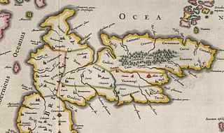
| Description | subregion of Image:Blaeu - Atlas of Scotland 1654 - INSULAE ALBION ET HIBERNIA - Old Great Britain.jpg, showing the territory of the Damnii | |||
| Date | ||||
| Source |
|
|||
| Author | Blaeu | |||
| Permission (Reusing this file) |
Public domain (70 years post mortem auctoris) | |||
| Other versions |
 |


|
This work is in the public domain in its country of origin and other countries and areas where the copyright term is the author's life plus 100 years or fewer. | |
| This file has been identified as being free of known restrictions under copyright law, including all related and neighboring rights. | |
File history
Click on a date/time to view the file as it appeared at that time.
| Date/Time | Thumbnail | Dimensions | User | Comment | |
|---|---|---|---|---|---|
| current | 21:14, 23 July 2008 | | 1,584 × 940 (318 KB) | Notuncurious (talk | contribs) | {{Information |Description=subregion of Image:Blaeu - Atlas of Scotland 1654 - INSULAE ALBION ET HIBERNIA - Old Great Britain.jpg, showing the territory of the Damnii |Source=same as full map - [http://www.nls.uk/maps/early/blaeu/blaeu_maps_index.htm |
You cannot overwrite this file.
File usage on Commons
The following page uses this file:
File usage on other wikis
The following other wikis use this file:
- Usage on en.wikipedia.org
- Usage on sl.wikipedia.org
- Usage on uk.wikipedia.org