File:BoerGriquaRepublics.svg

Size of this PNG preview of this SVG file: 800 × 400 pixels. Other resolutions: 320 × 160 pixels | 640 × 320 pixels | 1,024 × 512 pixels | 1,280 × 640 pixels | 2,560 × 1,280 pixels | 1,000 × 500 pixels.
Original file (SVG file, nominally 1,000 × 500 pixels, file size: 2.42 MB)
Captions
Captions
Map of Boer Republics
Summary edit
| Description |
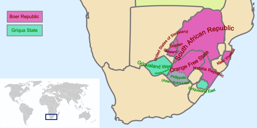
English: Map of Boer Republics and Griqua States, Southern Africa 19th century |
| Date | |
| Source | Own work |
| Author | Seb az86556 |
Licensing edit
I, the copyright holder of this work, hereby publish it under the following license:
This file is licensed under the Creative Commons Attribution 3.0 Unported license.
- You are free:
- to share – to copy, distribute and transmit the work
- to remix – to adapt the work
- Under the following conditions:
- attribution – You must give appropriate credit, provide a link to the license, and indicate if changes were made. You may do so in any reasonable manner, but not in any way that suggests the licensor endorses you or your use.
File history
Click on a date/time to view the file as it appeared at that time.
| Date/Time | Thumbnail | Dimensions | User | Comment | |
|---|---|---|---|---|---|
| current | 21:02, 20 May 2020 | | 1,000 × 500 (2.42 MB) | Seb az86556 (talk | contribs) | do not over write existing files / Reverted to version as of 15:30, 1 December 2010 (UTC) |
| 18:05, 2 March 2020 |  | 1,000 × 500 (3.33 MB) | Boershistory (talk | contribs) | {{Information |Description={{en|1=Map of Boer Republics and Griqua States, Southern Africa 19th century}} |Source=Own work by uploader |Author=Boershistory |Date=2020-03-02 |Permission= |other_versions= }} [[Category:History of South Africa}}]] text did not show on previous version | |
| 14:43, 2 March 2020 |  | 1,000 × 500 (3.05 MB) | Boershistory (talk | contribs) | {{Information |Description={{en|1=Map of Boer Republics and Griqua States, Southern Africa 19th century}} |Source=Own work by uploader |Author=Boershistory |Date=2020-03-02 |Permission= |other_versions= }} [[Category:History of South Africa}}]] | |
| 15:30, 1 December 2010 |  | 1,000 × 500 (2.42 MB) | Ras67 (talk | contribs) | border removed | |
| 02:58, 8 August 2009 |  | 1,000 × 500 (2.93 MB) | Seb az86556 (talk | contribs) | added text | |
| 02:52, 8 August 2009 |  | 1,000 × 500 (2.74 MB) | Seb az86556 (talk | contribs) | {{Information |Description={{en|1=Map of Boer Republics and Griqua States, Southern Africa 19th century}} |Source=Own work by uploader |Author=Seb az86556 |Date=2009-08-07 |Permission= |other_versions= }} [[Category:History of South |
You cannot overwrite this file.
File usage on Commons
The following 3 pages use this file:
File usage on other wikis
The following other wikis use this file:
- Usage on af.wikipedia.org
- Usage on br.wikipedia.org
- Usage on ca.wikipedia.org
- Usage on cs.wikipedia.org
- Usage on en.wikipedia.org
- Usage on en.wikivoyage.org
- Usage on eo.wikipedia.org
- Usage on es.wikipedia.org
- Usage on eu.wikipedia.org
- Usage on fi.wikipedia.org
- Usage on fr.wikipedia.org
- Usage on he.wikipedia.org
- Usage on id.wikipedia.org
- Usage on ja.wikipedia.org
- Usage on ko.wikipedia.org
- Usage on nl.wikipedia.org
- Usage on pt.wikipedia.org
- Usage on ru.wikipedia.org
- Usage on sr.wikipedia.org
- Usage on tum.wikipedia.org
- Usage on uk.wikipedia.org
- Usage on ur.wikipedia.org