File:Bombenedslag på Nyhavna og Ladehalvøya (1943) (18307737299).jpg

Original file (2,940 × 2,070 pixels, file size: 1.96 MB, MIME type: image/jpeg)
Captions
Captions
Summary edit
_(18307737299).jpg&action=edit§ion=1)
| Description |
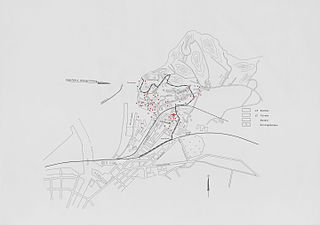
Format: Kart Dato / Date: 1943 Målestokk / Scale: Ukjent Kartograf / Cartographer: Antatt Wehrmacht Sted / Place: Nyhavna og Ladehalvøya, Trondheim Wikipedia: Strategisk bombing Wikipedia: Dora Litteratur: John I. Skjæran - Trondheim som bombemål (Trondheim 1986) - Varig lenke hos Nasjonalbiblioteket: urn.nb.no/URN:NBN:no-nb_digibok_2013062808047 Eier / Owner Institution: Trondheim byarkiv, The Municipal Archives of Trondheim Arkivreferanse / Archive reference: Tor.H22.R01 Merknad: Ubåtbunkeren Dora I ble ferdigstilt sommeren 1943 og tiltrakk seg oppmerksomhet fra de allierte. 24 juli 1943 kom 41 B-17 amerikanske 'Flying Fortress' bombefly over byen med det tyske anlegget i Nyhavna som mål. Klokken 13:37 gikk flyalarmen, og tyskerne satte i gang med å legge ut kunstig tåke. Tyske jagerfly ble sendt opp fra Lade flyplass for å imøtekomme bombeflyene. En stor mengde norske og utenlandske sivile arbeidere, tyskere og russiske krigsfanger søkte tilflukt i Dora. Kartet viser at bombeflyene kom inn fra vest over fjorden og at bombenedslagene var konsentrert til Nyhavna og Ladehalvøya, særskilt rundt Gassverket og det tyske anlegget på nordsiden av ubåtbunkeren i havnebassenget. Ladehammeren stakk opp over den kunstige tåken og kirkegården ved Lade kirke ble truffet. Bomber falt også innover helt mot Bromstad og Charlottenlund. 31 tyskere (12 sivile) og 8 nordmenn ble drept i angrepet. Rød farge er lagt til digitalt for å markere kartets inntegnede bombenedslag. |
|||||||||
| Source | Bombenedslag på Nyhavna og Ladehalvøya (1943) | |||||||||
| Creator |
Municipal Archives of Trondheim from Trondheim, Norway |
|||||||||
| Geotemporal data | ||||||||||
| Bounding box |
|
|||||||||
| Georeferencing | ||||||||||
| Camera location | | View this and other nearby images on: OpenStreetMap |
|---|
_(18307737299).jpg¶ms=063.440044_N_0010.422911_E_globe:Earth_type:camera_source:Flickr_&language=en)
Licensing edit
_(18307737299).jpg&action=edit§ion=2)
- You are free:
- to share – to copy, distribute and transmit the work
- to remix – to adapt the work
- Under the following conditions:
- attribution – You must give appropriate credit, provide a link to the license, and indicate if changes were made. You may do so in any reasonable manner, but not in any way that suggests the licensor endorses you or your use.
| This image was originally posted to Flickr by Trondheim byarkiv at https://flickr.com/photos/29160242@N08/18307737299. It was reviewed on 13 November 2015 by FlickreviewR and was confirmed to be licensed under the terms of the cc-by-2.0. |
File history
Click on a date/time to view the file as it appeared at that time.
| Date/Time | Thumbnail | Dimensions | User | Comment | |
|---|---|---|---|---|---|
| current | 17:17, 13 November 2015 | | 2,940 × 2,070 (1.96 MB) | Andrewrabbott (talk | contribs) | Transferred from Flickr via Flickr2Commons |
You cannot overwrite this file.
File usage on Commons
The following page uses this file:
File usage on other wikis
The following other wikis use this file:
- Usage on no.wikipedia.org
_(18307737299).jpg&oldid=828340590)