File:Borneo Locator Topography.png

Size of this preview: 553 × 599 pixels. Other resolutions: 221 × 240 pixels | 443 × 480 pixels | 709 × 768 pixels | 945 × 1,024 pixels | 1,605 × 1,739 pixels.
Original file (1,605 × 1,739 pixels, file size: 2.61 MB, MIME type: image/png)
Captions
Captions
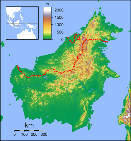
Topography Map of Borneo
Summary edit
| Description | Topographic locator map of Borneo. Created with GMT from public domain SRTM data. For non-locator version, see Image:Borneo Topography.png. Left:108 Bottom:-5 Right:120 Top:8 |
| Date | |
| Source | Own work |
| Author | Sadalmelik |
Licensing edit
I, the copyright holder of this work, hereby publish it under the following licenses:

|
Permission is granted to copy, distribute and/or modify this document under the terms of the GNU Free Documentation License, Version 1.2 or any later version published by the Free Software Foundation; with no Invariant Sections, no Front-Cover Texts, and no Back-Cover Texts. A copy of the license is included in the section entitled GNU Free Documentation License. |
This file is licensed under the Creative Commons Attribution-Share Alike 3.0 Unported, 2.5 Generic, 2.0 Generic and 1.0 Generic license.
- You are free:
- to share – to copy, distribute and transmit the work
- to remix – to adapt the work
- Under the following conditions:
- attribution – You must give appropriate credit, provide a link to the license, and indicate if changes were made. You may do so in any reasonable manner, but not in any way that suggests the licensor endorses you or your use.
- share alike – If you remix, transform, or build upon the material, you must distribute your contributions under the same or compatible license as the original.
You may select the license of your choice.
File history
Click on a date/time to view the file as it appeared at that time.
| Date/Time | Thumbnail | Dimensions | User | Comment | |
|---|---|---|---|---|---|
| current | 19:24, 1 September 2007 | | 1,605 × 1,739 (2.61 MB) | Sadalmelik (talk | contribs) | {{Information |Description=Topographic locator map of Borneo. Created wth GMT from public domain SRTM data. For non-locator version, see Image:Borneo Topography.png. Left:108 Bottom:-5 Right:120 Top:8 |Source=self-made |Date=Sep 1, 2007 |Author= [[Us |
You cannot overwrite this file.
File usage on Commons
The following page uses this file:
File usage on other wikis
The following other wikis use this file:
- Usage on ar.wikipedia.org
- Usage on ban.wikipedia.org
- Taman Nasional Gunung Palung
- Taman Nasional Tanjung Puting
- Celuk Balikpapan
- Lis taman nasional ring Indonésia
- Taman Nasional Bukit Baka Bukit Raya
- Taman Nasional Betung Kerihun
- Taman Nasional Danu Sentarum
- Taman Nasional Kutai
- Taman Nasional Kayan Mentarang
- Taman Nasional Gunung Mulu
- Song Jeriji Saléh
- Taman Nasional Pagunungan Crocker
- Taman Nasional Pabukitan Tawau
- Taman Nasional Nusa Tiga
- Usage on ba.wikipedia.org
- Usage on bn.wikipedia.org
- Usage on ceb.wikipedia.org
- Usage on cs.wikipedia.org
- Usage on da.wikipedia.org
- Usage on de.wikipedia.org
- Usage on en.wikipedia.org
- Tiga Island, Malaysia
- List of national parks in Malaysia
- Limbang
- Brunei International Airport
- Sipadan
- Ligitan
- Gunung Mulu National Park
- Samarinda
- Lawas
- Tabin Wildlife Reserve
- Tawau Hills National Park
- Tiga Island National Park
- Crocker Range National Park
- Tunku Abdul Rahman National Park
- Turtle Islands National Park (Malaysia)
- Tatau
- Kanowit
- Betong, Sarawak
- Batang Ai National Park
- Bako National Park
View more global usage of this file.