File:Bournemouth Borough Council election 2011 map.svg

Size of this PNG preview of this SVG file: 800 × 508 pixels. Other resolutions: 320 × 203 pixels | 640 × 406 pixels | 1,024 × 650 pixels | 1,280 × 812 pixels | 2,560 × 1,624 pixels | 1,425 × 904 pixels.
Original file (SVG file, nominally 1,425 × 904 pixels, file size: 265 KB)
Captions
Captions
Add a one-line explanation of what this file represents
| Description |
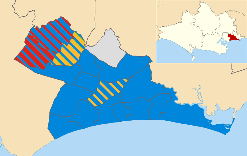
Map of Bournemouth, Dorset, UK showing the results of the 2011 local election. Colours: Conservative
Labour
Liberal Democrat
Independent
Striped wards have mixed representation. |
| Date | |
| Source |
|
| Author | Nilfanion |
| Permission (Reusing this file) |
This file is licensed under the Creative Commons Attribution-Share Alike 3.0 Unported license. Attribution: Contains Ordnance Survey data © Crown copyright and database right
|
File history
Click on a date/time to view the file as it appeared at that time.
| Date/Time | Thumbnail | Dimensions | User | Comment | |
|---|---|---|---|---|---|
| current | 22:50, 10 May 2011 | | 1,425 × 904 (265 KB) | Nilfanion (talk | contribs) | {{Information |Description=Map of Bournemouth, Dorset, UK showing the results of the 2011 local election. Colours: {{legend|#0087dc|Conservative}} {{legend|#dc241f|Labour}} {{legend|#fdbb30|Liberal Democrat}} {{legend|#dddddd|Independent}} Striped wards |
You cannot overwrite this file.
File usage on Commons
There are no pages that use this file.
File usage on other wikis
The following other wikis use this file:
- Usage on en.wikipedia.org
- Usage on www.wikidata.org