File:Breaker Bay Map.png

Size of this preview: 750 × 600 pixels. Other resolutions: 300 × 240 pixels | 600 × 480 pixels | 829 × 663 pixels.
Original file (829 × 663 pixels, file size: 167 KB, MIME type: image/png)
Captions
Captions
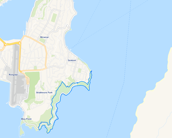
A map showing the suburb Breaker Bay outlined in blue.
Summary edit
| Description |
English: A map showing the suburb Breaker Bay outlined in blue. The suburb is sitting on the southeast coast of Mirimar Peninsula, with Wainuomata to its east across the Wellington Harbour entrance. |
| Date | |
| Source | Edited map derived from Wellington City Council's map of suburbs and wards, at https://gis.wcc.govt.nz/LocalMaps/Viewer/?map=64d3db16816a48579297270c9d45753e. |
| Author | Wellington City Council |
Licensing edit
This file is licensed under the Creative Commons Attribution-Share Alike 4.0 International license.
- You are free:
- to share – to copy, distribute and transmit the work
- to remix – to adapt the work
- Under the following conditions:
- attribution – You must give appropriate credit, provide a link to the license, and indicate if changes were made. You may do so in any reasonable manner, but not in any way that suggests the licensor endorses you or your use.
- share alike – If you remix, transform, or build upon the material, you must distribute your contributions under the same or compatible license as the original.
File history
Click on a date/time to view the file as it appeared at that time.
| Date/Time | Thumbnail | Dimensions | User | Comment | |
|---|---|---|---|---|---|
| current | 22:52, 30 November 2021 | | 829 × 663 (167 KB) | HenryCrun15 (talk | contribs) | Cleaner map - removed red coloring that was indicating ward boundaries |
| 22:11, 30 November 2021 |  | 867 × 640 (133 KB) | HenryCrun15 (talk | contribs) | Uploaded a work by Wellington City Council from Edited map derived from Wellington City Council's map of suburbs and wards, at https://gis.wcc.govt.nz/LocalMaps/Viewer/?map=64d3db16816a48579297270c9d45753e. with UploadWizard |
You cannot overwrite this file.
File usage on Commons
There are no pages that use this file.
File usage on other wikis
The following other wikis use this file:
- Usage on en.wikipedia.org