File:Brecha-hidrica.svg

Original file (SVG file, nominally 697 × 469 pixels, file size: 86 KB)
Captions
Captions
Summary edit
| Description |
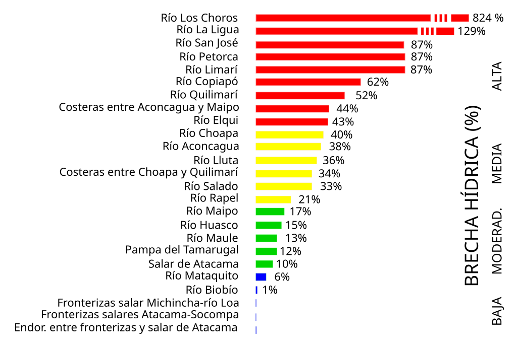
Español: En el informe Radiografía del Agua (Escenarios Hídricos 2030, 2018) se realizó un
análisis de la brecha hídrica mediante un índice que compara la oferta con la demanda, en este caso la demanda se caracteriza por los derechos de aprovechamiento de Aguas (DAA), la captación de aguas y el consumo de agua. Estos últimos dos fueron estimados, a escala de comuna, en el estudio de Huella Hídrica Nacional realizado por Jaramillo y Acevedo (2017). Los resultados del análisis finalmente fueron agrupados a nivel de cuenca, donde se consideraron 25 de las 101 cuencas existentes a nivel nacional (Figura 2.9). |
| Date | |
| Source |
https://estudiosurbanos.uc.cl/wp-content/uploads/2022/12/2022_Com-Cambio-Climatico_Informe-Desalinizacion_vfinal_compressed.pdf page 32 . Originally from https://escenarioshidricos.cl/wp-content/uploads/2020/06/radiografia-del-agua-1.pdf |
| Author |
Escenarios Hídricos 2030. (2018). Radiografía del Agua: Brecha y Riesgo Hídrico en Chile. https://escenarioshidricos. cl/publicacion/radiografia-del-agua-brecha-y-riesgo-hidrico-en-chile/ |
| Other versions | File:Brecha-hidrica.gif |
Licensing edit
- You are free:
- to share – to copy, distribute and transmit the work
- to remix – to adapt the work
- Under the following conditions:
- attribution – You must give appropriate credit, provide a link to the license, and indicate if changes were made. You may do so in any reasonable manner, but not in any way that suggests the licensor endorses you or your use.
- share alike – If you remix, transform, or build upon the material, you must distribute your contributions under the same or compatible license as the original.
File history
Click on a date/time to view the file as it appeared at that time.
| Date/Time | Thumbnail | Dimensions | User | Comment | |
|---|---|---|---|---|---|
| current | 11:35, 16 November 2023 | | 697 × 469 (86 KB) | Juan Villalobos (talk | contribs) | other attempt |
| 11:33, 16 November 2023 |  | 697 × 469 (86 KB) | Juan Villalobos (talk | contribs) | Separate text from bars. wider. | |
| 15:22, 18 September 2023 |  | 678 × 469 (89 KB) | Juan Villalobos (talk | contribs) | Uploaded own work with UploadWizard |
You cannot overwrite this file.
File usage on Commons
There are no pages that use this file.
File usage on other wikis
The following other wikis use this file:
- Usage on es.wikipedia.org
- Pampa del Tamarugal
- Quebrada de Azapa
- Río La Ligua
- Río Salado (Chañaral)
- Río Quilimarí
- Quebrada Los Choros
- Cuenca del río Maipo
- Cuenca del río Biobío
- Cuenca del río Maule
- Cuenca del río Limarí
- Cuenca del río Rapel
- Cuenca del río Lluta
- Cuenca del río Copiapó
- Cuenca del río Mataquito
- Cuenca del río Elqui
- Cuenca del río Choapa
- Cuenca del río Aconcagua
- Cuenca del salar de Atacama
- Cuenca del río Petorca
- Cuencas costeras entre río Choapa y río Quilimarí