File:Bremer Dombezirk - Johann Christian Dankwerth - 1750.jpg

Size of this preview: 687 × 599 pixels. Other resolutions: 275 × 240 pixels | 550 × 480 pixels | 881 × 768 pixels | 1,174 × 1,024 pixels | 1,447 × 1,262 pixels.
Original file (1,447 × 1,262 pixels, file size: 1.08 MB, MIME type: image/jpeg)
Captions
Captions
Add a one-line explanation of what this file represents
Summary edit
| Description |
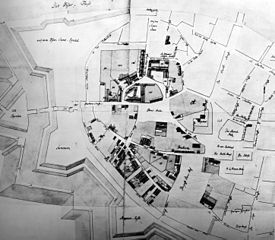
English: Grundriß der Altstadt Bremen. Map by Johann Christian Dankwerth from the year 1750, showing the posessions of the state of Hanover in the city of Bremen (the Dombezirk, the “cathedral district“).
Deutsch: Grundriß der Altstadt Bremen. Karte von Johann Christian Dankwerth aus dem Jahr 1750, die die hannoverschen Besitzungen (den Dombezirk) in Bremen zeigt. |
| Date | |
| Source | Wilhelm Lührs: Der Domshof. Geschichte eines bremischen Platzes. Verlag Hauschild, Bremen 1987. |
| Author | Johann Christian Dankwerth |
Licensing edit
|
This work is in the public domain in its country of origin and other countries and areas where the copyright term is the author's life plus 100 years or fewer. | |
| This file has been identified as being free of known restrictions under copyright law, including all related and neighboring rights. | |
File history
Click on a date/time to view the file as it appeared at that time.
| Date/Time | Thumbnail | Dimensions | User | Comment | |
|---|---|---|---|---|---|
| current | 10:30, 15 November 2010 | | 1,447 × 1,262 (1.08 MB) | Gepardenforellenfischer (talk | contribs) | {{Information |Description={{en|1=''Grundriß der Altstadt Bremen''. Map by Johann Christian Dankwerth from the year 1750, showing the posessions of the state of Hanover in the city of Bremen (the ''Dombezirk'', the “cathedral district“).}} {{de|1=''G |
You cannot overwrite this file.
File usage on Commons
The following page uses this file:
File usage on other wikis
The following other wikis use this file:
- Usage on de.wikipedia.org