File:Brick apartment buildings with arched window openings, string courses, a brick cornice, and an interrupted brick frieze. - Butte Historic District, Bounded by Copper, Arizona, HAER MONT,47-BUT,1-28.tif

Size of this JPG preview of this TIF file: 478 × 599 pixels. Other resolutions: 191 × 240 pixels | 383 × 480 pixels | 613 × 768 pixels | 817 × 1,024 pixels | 1,635 × 2,048 pixels | 3,732 × 4,675 pixels.
Original file (3,732 × 4,675 pixels, file size: 16.64 MB, MIME type: image/tiff)
Captions
Captions
Add a one-line explanation of what this file represents
Summary edit
| Brick apartment buildings with arched window openings, string courses, a brick cornice, and an interrupted brick frieze. - Butte Historic District, Bounded by Copper, Arizona, Mercury and Continental Streets, Butte, Silver Bow County, MT | ||||
|---|---|---|---|---|
| Photographer |
Related names:
|
|||
| Title |
Brick apartment buildings with arched window openings, string courses, a brick cornice, and an interrupted brick frieze. - Butte Historic District, Bounded by Copper, Arizona, Mercury and Continental Streets, Butte, Silver Bow County, MT |
|||
| Depicted place | Montana; Silver Bow County; Butte | |||
| Date | Documentation compiled after 1968 | |||
| Dimensions | 4 x 5 in. | |||
| Current location |
Library of Congress Prints and Photographs Division Washington, D.C. 20540 USA http://hdl.loc.gov/loc.pnp/pp.print |
|||
| Accession number |
HAER MONT,47-BUT,1-28 |
|||
| Credit line |
|
|||
| Notes |
|
|||
| References |
|
|||
| Source | https://www.loc.gov/pictures/item/mt0040.photos.101074p | |||
| Permission (Reusing this file) |
|
|||

| Object location | | View this and other nearby images on: OpenStreetMap |
|---|
File history
Click on a date/time to view the file as it appeared at that time.
| Date/Time | Thumbnail | Dimensions | User | Comment | |
|---|---|---|---|---|---|
| current | 12:39, 25 July 2014 | 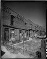 | 3,732 × 4,675 (16.64 MB) | Fæ (talk | contribs) | GWToolset: Creating mediafile for Fæ. HABS 24 July 2014 (2001:2300) |
You cannot overwrite this file.
File usage on Commons
The following page uses this file: