File:Bristol.svg

Size of this PNG preview of this SVG file: 791 × 600 pixels. Other resolutions: 317 × 240 pixels | 633 × 480 pixels | 1,013 × 768 pixels | 1,280 × 970 pixels | 2,560 × 1,941 pixels | 1,364 × 1,034 pixels.
Original file (SVG file, nominally 1,364 × 1,034 pixels, file size: 251 KB)
Captions
Captions
Add a one-line explanation of what this file represents
| Description |
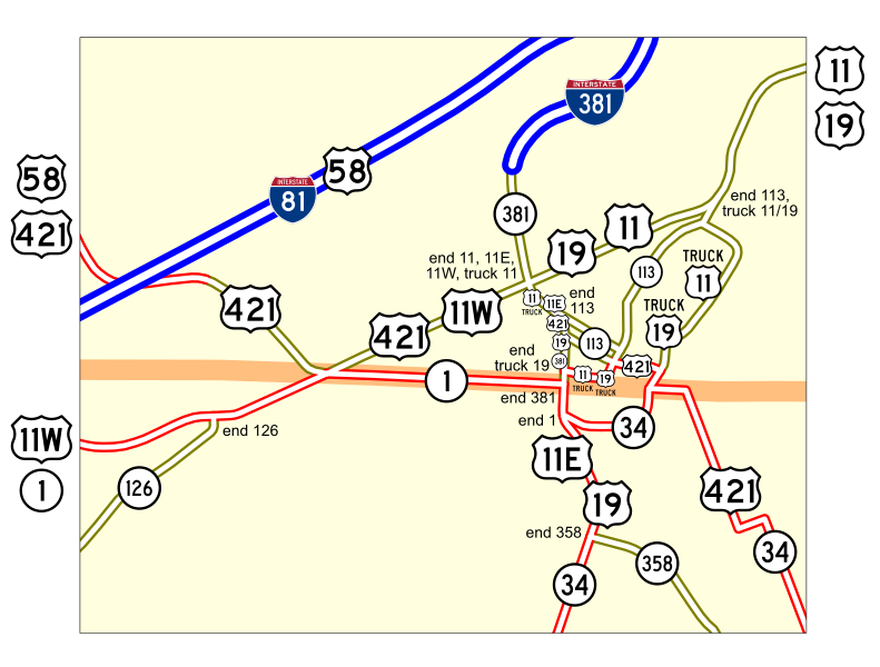
Map of numbered routes in Bristol, Tennessee-Virginia. Traced on USGS topos.
|
||
| Date | _2004. | ||
| Source | http://www.tdot.state.tn.us/ | ||
| Author | User:SPUI | ||
| Permission (Reusing this file) |
|
File history
Click on a date/time to view the file as it appeared at that time.
| Date/Time | Thumbnail | Dimensions | User | Comment | |
|---|---|---|---|---|---|
| current | 19:36, 2 June 2006 | | 1,364 × 1,034 (251 KB) | SPUI~commonswiki (talk | contribs) | gahhh |
| 19:35, 2 June 2006 |  | 1,364 × 1,034 (251 KB) | SPUI~commonswiki (talk | contribs) | oops again | |
| 19:34, 2 June 2006 |  | 1,364 × 1,034 (251 KB) | SPUI~commonswiki (talk | contribs) | oops again | |
| 19:32, 2 June 2006 |  | 1,364 × 1,034 (251 KB) | SPUI~commonswiki (talk | contribs) | oops | |
| 19:25, 2 June 2006 |  | 1,364 × 1,034 (2.71 MB) | SPUI~commonswiki (talk | contribs) | {{spuimap}} Map of numbered routes in Bristol, Tennessee-Virginia. Traced on USGS topos. Information is from [http://www.tdot.state.tn.us/Maps/city/Bristol.PDF] and [http://www.virginiadot.org/comtravel/resources/AADT_102_Bristol_2004.pdf]. *Blue: Interst |
You cannot overwrite this file.
File usage on Commons
The following 2 pages use this file:
File usage on other wikis
The following other wikis use this file:
- Usage on en.wikipedia.org
- Usage on www.wikidata.org