File:Bristol - Park Street (geograph 4616235).jpg

Size of this preview: 398 × 599 pixels. Other resolutions: 159 × 240 pixels | 319 × 480 pixels | 510 × 768 pixels | 680 × 1,024 pixels | 1,361 × 2,048 pixels | 2,604 × 3,919 pixels.
Original file (2,604 × 3,919 pixels, file size: 7.22 MB, MIME type: image/jpeg)
Captions
Captions
Add a one-line explanation of what this file represents
Summary edit
.jpg&action=edit§ion=1)
| Description |
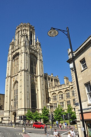
English: Situated near the top of Park Street on Queens Road in Bristol, the Wills Tower is a landmark building of the University of Bristol that currently houses the School of Law and the Department of Earth Sciences, as well as the Law and Earth Sciences libraries. It is the third highest structure in Bristol, standing at 215 ft (65.5 m). |
| Date | |
| Source | From geograph.org.uk |
| Author | Lewis Clarke |
| Permission (Reusing this file) |
Creative Commons Attribution Share-alike license 2.0 |
| Attribution (required by the license) | Lewis Clarke / Bristol : Park Street / |
| Camera location | | View this and other nearby images on: OpenStreetMap |
|---|
.jpg¶ms=051.455510_N_-002.604021_E_globe:Earth_type:camera_source:geograph-osgb36(ST5812873121)_heading:315.00&language=en)
| Object location | | View this and other nearby images on: OpenStreetMap |
|---|
.jpg¶ms=051.455680_N_-002.604280_E_globe:Earth_class:object_type:object_source:geograph-osgb36(ST58117314)_heading:315.00&language=en)
Licensing edit
.jpg&action=edit§ion=2)

|
This image was taken from the Geograph project collection. See this photograph's page on the Geograph website for the photographer's contact details. The copyright on this image is owned by Lewis Clarke and is licensed for reuse under the Creative Commons Attribution-ShareAlike 2.0 license.
|
This file is licensed under the Creative Commons Attribution-Share Alike 2.0 Generic license.
Attribution: Lewis Clarke
- You are free:
- to share – to copy, distribute and transmit the work
- to remix – to adapt the work
- Under the following conditions:
- attribution – You must give appropriate credit, provide a link to the license, and indicate if changes were made. You may do so in any reasonable manner, but not in any way that suggests the licensor endorses you or your use.
- share alike – If you remix, transform, or build upon the material, you must distribute your contributions under the same or compatible license as the original.
File history
Click on a date/time to view the file as it appeared at that time.
| Date/Time | Thumbnail | Dimensions | User | Comment | |
|---|---|---|---|---|---|
| current | 16:47, 6 February 2023 | | 2,604 × 3,919 (7.22 MB) | Chocolateediter (talk | contribs) | == {{int:filedesc}} == {{Information |Description={{en|1= Situated near the top of Park Street on Queens Road in Bristol, the Wills Tower is a landmark building of the University of Bristol that currently houses the School of Law and the Department of Earth Sciences, as well as the Law and Earth Sciences libraries. It is the third highest structure in Bristol, standing at 215 ft (65.5 m).}} |Source=From [https://www.geograph.org.uk/photo/4616235 geograph.org.uk] |Date=2015-07-19 |Author=[http... |
You cannot overwrite this file.
File usage on Commons
There are no pages that use this file.
.jpg&oldid=834065427)