File:British Empire Map (Chinese).svg

Size of this PNG preview of this SVG file: 800 × 406 pixels. Other resolutions: 320 × 162 pixels | 640 × 324 pixels | 1,024 × 519 pixels | 1,280 × 649 pixels | 2,560 × 1,298 pixels | 939 × 476 pixels.
Original file (SVG file, nominally 939 × 476 pixels, file size: 1.7 MB)
Captions
Captions
Add a one-line explanation of what this file represents
Summary edit
.svg&action=edit§ion=1)
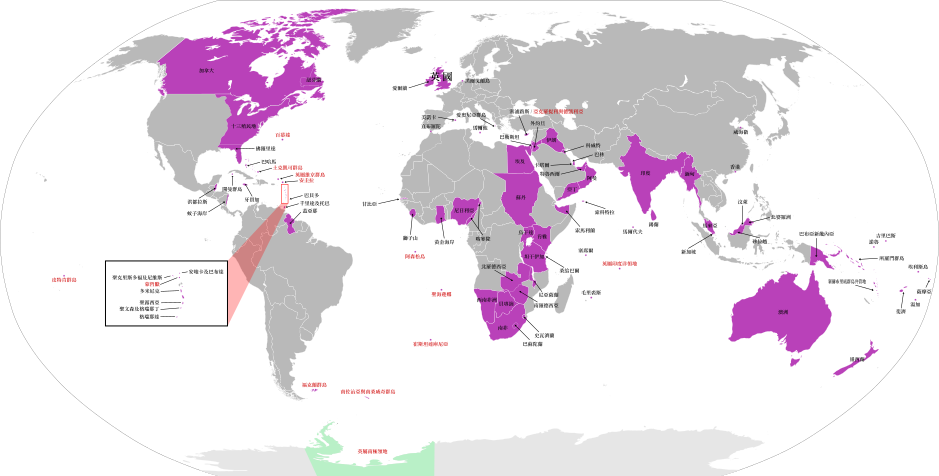
| Description | |
| Date | |
| Source | |
| Author |
With reference with The Red Hat of Pat Ferrick's work Vectorize by Momocalbee |
| Other versions |
The British Empire.png The British Empire (including Crown Dependencies, Crown Colonies-Overseas Territories, Protectorates, Military Administrations).png The British Empire1.png |
.png)
Licensing edit
.svg&action=edit§ion=2)
| I, the copyright holder of this work, release this work into the public domain. This applies worldwide. In some countries this may not be legally possible; if so: I grant anyone the right to use this work for any purpose, without any conditions, unless such conditions are required by law. |
File history
Click on a date/time to view the file as it appeared at that time.
| Date/Time | Thumbnail | Dimensions | User | Comment | |
|---|---|---|---|---|---|
| current | 14:35, 18 July 2016 | | 939 × 476 (1.7 MB) | Nv7801 (talk | contribs) | Fix the position of sierra leone |
| 09:10, 26 June 2016 |  | 939 × 476 (1.7 MB) | Nv7801 (talk | contribs) | Add back Bahrain | |
| 08:42, 26 June 2016 |  | 939 × 476 (1.7 MB) | Nv7801 (talk | contribs) | Fix some words | |
| 08:40, 26 June 2016 |  | 939 × 476 (1.64 MB) | Nv7801 (talk | contribs) | User created page with UploadWizard |
You cannot overwrite this file.
File usage on Commons
The following page uses this file:
.svg)
.svg&oldid=834289231)