File:British Isles mk.svg

Size of this PNG preview of this SVG file: 360 × 600 pixels. Other resolutions: 144 × 240 pixels | 288 × 480 pixels | 461 × 768 pixels | 615 × 1,024 pixels | 1,230 × 2,048 pixels | 1,297 × 2,160 pixels.
Original file (SVG file, nominally 1,297 × 2,160 pixels, file size: 536 KB)
Captions
Captions
Add a one-line explanation of what this file represents
Summary edit
| Description |
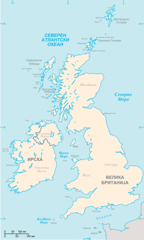
Македонски: Карта на Британските Острови.
Секогаш се сметаат за дел од Британските Острови
Понекогаш се сметаат за дел од Британските Острови
Други земји English: Map of the British Isles in Macedonian. |
| Date | (UTC) |
| Source | |
| Author |
|
| Other versions |
|

| This is a retouched picture, which means that it has been digitally altered from its original version. Modifications: Translated to Macedonian. The original can be viewed here: British Isles.svg:
|
Licensing edit
I, the copyright holder of this work, hereby publish it under the following licenses:
| This file is licensed under the Creative Commons Attribution-Share Alike 3.0 Unported license. | ||
| ||
| This licensing tag was added to this file as part of the GFDL licensing update. |

|
Permission is granted to copy, distribute and/or modify this document under the terms of the GNU Free Documentation License, Version 1.2 or any later version published by the Free Software Foundation; with no Invariant Sections, no Front-Cover Texts, and no Back-Cover Texts. A copy of the license is included in the section entitled GNU Free Documentation License. |
You may select the license of your choice.
Original upload log edit
This image is a derivative work of the following images:
- File:British_Isles.svg licensed with Cc-by-sa-3.0-migrated, GFDL
- 2006-08-20T12:37:29Z Smurrayinchester 1297x2160 (200540 Bytes) An SVG map of the British Isles, with the largest islands and archipelagos labeled. {{legend|#fff0de|Always considered part of the British Isles|border=#ffffff}} {{legend|#ffb380|Sometimes considered part of the British Isle
Uploaded with derivativeFX
File history
Click on a date/time to view the file as it appeared at that time.
| Date/Time | Thumbnail | Dimensions | User | Comment | |
|---|---|---|---|---|---|
| current | 11:49, 3 January 2012 | | 1,297 × 2,160 (536 KB) | Bjankuloski06en (talk | contribs) | == {{int:filedesc}} == {{Information |Description={{mk|1=Карта на Британските Острови. {{legend|#fff0de|Секогаш се сметаат за дел од Британските Остр� |
You cannot overwrite this file.
File usage on Commons
The following 2 pages use this file:
File usage on other wikis
The following other wikis use this file:
- Usage on fr.wiktionary.org
- Usage on mk.wikipedia.org