File:Broad Trunk Run Aqueduct at 31.9 miles on C and O Canal from LOC.tif

Size of this JPG preview of this TIF file: 800 × 573 pixels. Other resolutions: 320 × 229 pixels | 640 × 458 pixels | 1,024 × 733 pixels | 1,280 × 916 pixels | 2,560 × 1,832 pixels | 5,000 × 3,579 pixels.
Original file (5,000 × 3,579 pixels, file size: 17.07 MB, MIME type: image/tiff)
Captions
Captions
Add a one-line explanation of what this file represents
Summary edit
| Description |
English: Looking upstream ("north") on the Broad Run Trunk Aqueduct, at 31.9 miles (just above Edwards Ferry) on the Chesapeake and Ohio Canal. This was originally a double culvert (#44 1/2) converted to a wooden aqueduct, the only one of its kind on the canal. |
|||||
| Source |
|
|||||
| Author | Historic American Buildings Survey | |||||
| Permission (Reusing this file) |
|
|||||
| Other versions |
|


| Camera location | | View this and other nearby images on: OpenStreetMap |
|---|
[
Licensing edit
This work is in the public domain in the United States because it is a work prepared by an officer or employee of the United States Government as part of that person’s official duties under the terms of Title 17, Chapter 1, Section 105 of the US Code.
Note: This only applies to original works of the Federal Government and not to the work of any individual U.S. state, territory, commonwealth, county, municipality, or any other subdivision. This template also does not apply to postage stamp designs published by the United States Postal Service since 1978. (See § 313.6(C)(1) of Compendium of U.S. Copyright Office Practices). It also does not apply to certain US coins; see The US Mint Terms of Use.
|
 | |
| This file has been identified as being free of known restrictions under copyright law, including all related and neighboring rights. | ||
File history
Click on a date/time to view the file as it appeared at that time.
| Date/Time | Thumbnail | Dimensions | User | Comment | |
|---|---|---|---|---|---|
| current | 03:36, 9 September 2013 | 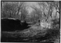 | 5,000 × 3,579 (17.07 MB) | Bonnachoven (talk | contribs) | {{Information |Description ={{en|1=Looking upstream ("north") on the Broad Trunk Run Aqueduct, at 31.9 miles (just above Edwards Ferry) on the Chesapeake and Ohio Canal. This was originally a double culvert (44 1/2) converted to a wooden aqueduct, t... |
You cannot overwrite this file.
File usage on Commons
The following 2 pages use this file:
File usage on other wikis
The following other wikis use this file:
- Usage on en.wikipedia.org