File:Brussels Hoofdstedelijk GewestGemeenten.png
Brussels_Hoofdstedelijk_GewestGemeenten.png (270 × 203 pixels, file size: 5 KB, MIME type: image/png)
Captions
Captions

|
This locator map image could be re-created using vector graphics as an SVG file. This has several advantages; see Commons:Media for cleanup for more information. If an SVG form of this image is available, please upload it and afterwards replace this template with
{{vector version available|new image name}}.
It is recommended to name the SVG file “Brussels Hoofdstedelijk GewestGemeenten.svg”—then the template Vector version available (or Vva) does not need the new image name parameter. |
Summary edit
| Description |
Lëtzebuergesch: Gemenge vun der Haaptstadregioun Bréissel
Nederlands: NL; kaart gemaakt door w:nl:gebruiker:LennartBolks in in het publieke domein geplaatst
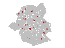
Kaart van de gemeenten van het w:nl:Brussels Hoofdstedelijk Gewest De 19 gemeenten van het w:nl:Brussels Hoofdstedelijk Gewest (met hun postcodes):
Français : FR; carte créée et dédiée au domaine public par w:nl:gebruiker:LennartBolks
Carte des communes de la w:fr:région de Bruxelles-Capitale. Les 19 communes de la w:fr:région de Bruxelles-Capitale et leurs codes postaux :
|
| Source | Transferred from nl.wikipedia: nl:Afbeelding:Brussels_Hoofdstedelijk_GewestGemeenten.png. |
| Author | w:nl:gebruiker:LennartBolks |
Licensing edit
| This work has been released into the public domain by its author, LennartBolks. This applies worldwide. In some countries this may not be legally possible; if so: |
File history
Click on a date/time to view the file as it appeared at that time.
| Date/Time | Thumbnail | Dimensions | User | Comment | |
|---|---|---|---|---|---|
| current | 15:06, 13 December 2004 | | 270 × 203 (5 KB) | Walter (talk | contribs) | {{PD}} |
You cannot overwrite this file.
File usage on Commons
The following 4 pages use this file:
File usage on other wikis
The following other wikis use this file:
- Usage on af.wikipedia.org
- Usage on avk.wikipedia.org
- Usage on av.wikipedia.org
- Usage on bg.wikipedia.org
- Usage on bs.wikipedia.org
- Usage on ca.wikipedia.org
- Usage on de.wikivoyage.org
- Usage on eo.wikipedia.org
- Usage on et.wikipedia.org
- Usage on eu.wikipedia.org
- Usage on frr.wikipedia.org
- Usage on fr.wikipedia.org
- Usage on fy.wikipedia.org
- Usage on hr.wikipedia.org
- Usage on it.wikipedia.org
- Usage on lb.wikipedia.org
- Usage on li.wikipedia.org
- Usage on nl.wikipedia.org
- Usage on oc.wikipedia.org
View more global usage of this file.