File:Bulgaria Gabrovo Province relief location map.jpg
No higher resolution available.
Bulgaria_Gabrovo_Province_relief_location_map.jpg (366 × 300 pixels, file size: 54 KB, MIME type: image/jpeg)
Captions
Captions
Add a one-line explanation of what this file represents
| Description |
|
| Date | |
| Source |
Own work
|
| Author | Ikonact |
| Other versions |
|

I, the copyright holder of this work, hereby publish it under the following licenses:

|
Permission is granted to copy, distribute and/or modify this document under the terms of the GNU Free Documentation License, Version 1.2 or any later version published by the Free Software Foundation; with no Invariant Sections, no Front-Cover Texts, and no Back-Cover Texts. A copy of the license is included in the section entitled GNU Free Documentation License. |
This file is licensed under the Creative Commons Attribution-Share Alike 4.0 International, 3.0 Unported, 2.5 Generic, 2.0 Generic and 1.0 Generic license.
- You are free:
- to share – to copy, distribute and transmit the work
- to remix – to adapt the work
- Under the following conditions:
- attribution – You must give appropriate credit, provide a link to the license, and indicate if changes were made. You may do so in any reasonable manner, but not in any way that suggests the licensor endorses you or your use.
- share alike – If you remix, transform, or build upon the material, you must distribute your contributions under the same or compatible license as the original.
You may select the license of your choice.
File history
Click on a date/time to view the file as it appeared at that time.
| Date/Time | Thumbnail | Dimensions | User | Comment | |
|---|---|---|---|---|---|
| current | 20:42, 28 May 2013 | | 366 × 300 (54 KB) | Ikonact (talk | contribs) | lower size. Previous size does not correspond to SRTM data resolution |
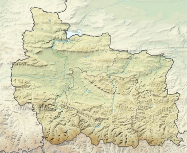
| 21:16, 22 May 2013 |  | 610 × 500 (130 KB) | Ikonact (talk | contribs) | {{Information |description={{en|1=Relief Location map Gabrovo Province, Bulgaria. Geographic limits of the map:}} {{bg|1=Позиционна релефна карта на [[:bg:Област Габрово|о... |
You cannot overwrite this file.
File usage on Commons
The following page uses this file:
File usage on other wikis
The following other wikis use this file:
- Usage on bg.wikipedia.org
- Габрово
- Плачковци
- Трявна
- Севлиево
- Дряново
- Габрово (област)
- Ангелов (село)
- Армените
- Баланите
- Балиновци
- Банковци
- Бекриите
- Беломъжите
- Бобевци
- Богданчовци
- Боженците
- Бойновци
- Болтата
- Борики
- Борското
- Брънеците
- Бялково
- Бойчета
- Ветрово
- Влайчовци
- Врабците
- Враниловци
- Вълков дол
- Гайкини
- Гайтаните
- Геновци
- Генчовци (община Габрово)
- Гергини
- Гледаци
- Горнова могила
- Гръблевци
- Гъбене
- Дебел дял
- Джумриите
- Дивеци
- Донино
- Драганчетата
- Драгиевци
- Драгомани
- Думници
- Езерото
- Живко (село)
- Жълтеш
- Здравковец
- Зелено дърво
View more global usage of this file.