File:Bulgarian motorway network en.svg

Size of this PNG preview of this SVG file: 676 × 453 pixels. Other resolutions: 320 × 214 pixels | 640 × 429 pixels | 1,024 × 686 pixels | 1,280 × 858 pixels | 2,560 × 1,716 pixels.
Original file (SVG file, nominally 676 × 453 pixels, file size: 264 KB)
Captions
Captions
Add a one-line explanation of what this file represents
Summary edit
| Description |
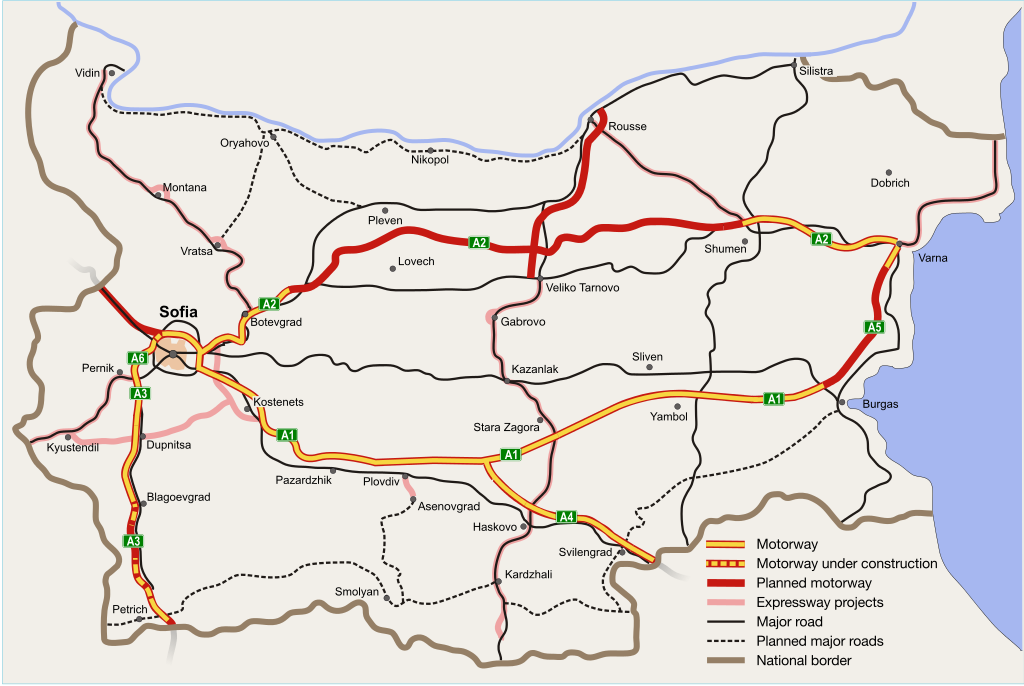
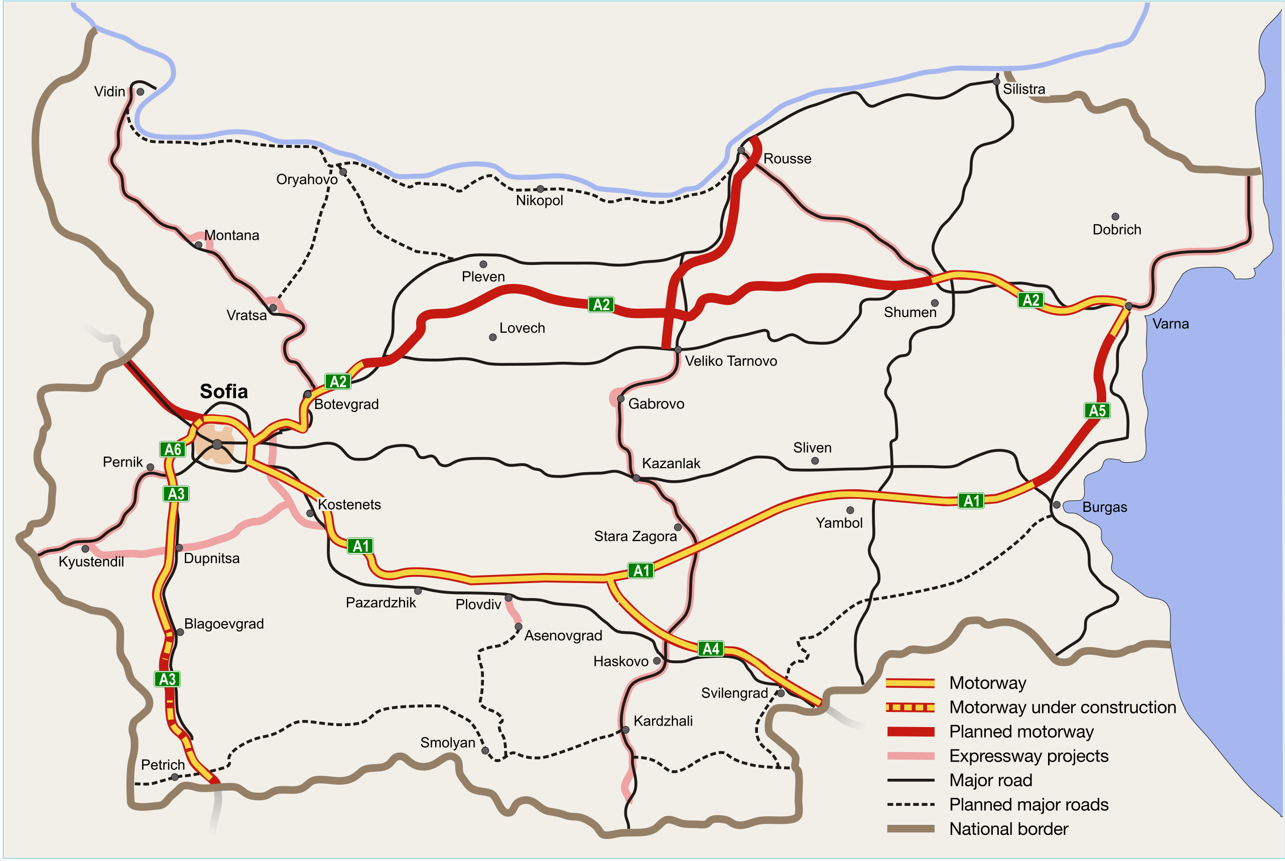
Deutsch: Autobahnnetz in Bulgarien English: Motorway network of Bulgaria Български: Автомагистрали в България |
| Date | |
| Source |
Own work Based on Image:Bulgarian road network.svg by Cassini83 |
| Author |
Dragomir Keranov Update March 2011: Maximilian Dörrbecker (Chumwa) |
| Other versions |
|
| SVG development |


References edit
- Доклад на Министерството на транспорта - Развитие на устойчива транспортна система в Република България 2007-2020 г., стр.15 (Bulgarian Ministry of Transport Report on the Development of a Stable Transport System in the Republic of Bulgaria 2007-2020, p.15)
- Фонд "Републиканска пътна инфраструктура" - Общи карти[dead link] (Republican Road Infrastructure Fund - General Maps)
- Аз спасявам живот. Инициатива за пътна безопасност 2007-2010 г.: Карта с опасни участъци (I Save a Life. Road Safety Initiative 2007-2010: Dangerous areas)
- Министерство на регионалното развитие и благоустройството: ПРИОРИТЕТИ ЗА ИЗГРАЖДАНЕ НА ПЪТНАТА ИНФРАСТРУКТУРА НА РЕПУБЛИКА БЪЛГАРИЯ ДО 2020 ГОДИНА ЗА ПЪТИЩАТА С ОБЩОЕВРОПЕЙСКО И НАЦИОНАЛНО ЗНАЧЕНИЕ (24 януари 2011)
- РЕШЕНИЕ № 666 ОТ 6 АВГУСТ 2012 Г. за изменение и допълнение на Решение № 945 на Министерския съвет от 2004 г. за утвърждаване Списък на републиканските пътища, приемане Списък на републиканските пътища, за които се събира такса за ползване на пътната инфраструктура – винетна такса, и за определяне на съоръжение, за което се събира такса по чл. 10, ал. 4 от Закона за пътищата за ползване на отделно съоръжение по републиканските пътища (State Gazette, issue 61 from 10.08.2012 - Resolution of Council of Ministers about the roads which require vignette to travel)
Licensing edit
I, the copyright holder of this work, hereby publish it under the following licenses:

|
Permission is granted to copy, distribute and/or modify this document under the terms of the GNU Free Documentation License, Version 1.2 or any later version published by the Free Software Foundation; with no Invariant Sections, no Front-Cover Texts, and no Back-Cover Texts. A copy of the license is included in the section entitled GNU Free Documentation License. |
This file is licensed under the Creative Commons Attribution-Share Alike 3.0 Unported license.
- You are free:
- to share – to copy, distribute and transmit the work
- to remix – to adapt the work
- Under the following conditions:
- attribution – You must give appropriate credit, provide a link to the license, and indicate if changes were made. You may do so in any reasonable manner, but not in any way that suggests the licensor endorses you or your use.
- share alike – If you remix, transform, or build upon the material, you must distribute your contributions under the same or compatible license as the original.
You may select the license of your choice.
File history
Click on a date/time to view the file as it appeared at that time.
| Date/Time | Thumbnail | Dimensions | User | Comment | |
|---|---|---|---|---|---|
| current | 09:42, 30 April 2016 | | 676 × 453 (264 KB) | Gogo303 (talk | contribs) | SNST completed |
| 08:05, 29 October 2015 |  | 676 × 453 (264 KB) | Gogo303 (talk | contribs) | Opened: A3 Dupnitsa-Blagoevgrad, A4 Chirpan-Dimitrovgrad, part of west arc of SRR. U/C: another part of west arc, A3 Kresna-Sandanski | |
| 06:46, 4 August 2015 |  | 676 × 453 (263 KB) | Gogo303 (talk | contribs) | A2, Belokopitovo I/C is inaugurated | |
| 15:20, 31 July 2015 |  | 676 × 453 (263 KB) | Gogo303 (talk | contribs) | lot 4 of A3 opens, Ruse-VT project added | |
| 08:05, 28 May 2015 |  | 676 × 453 (263 KB) | Gogo303 (talk | contribs) | Haskovo-Harmanli opens | |
| 07:44, 17 February 2014 |  | 676 × 453 (263 KB) | Gogo303 (talk | contribs) | Sofia Northern Bypass U/C | |
| 13:33, 18 August 2013 |  | 676 × 453 (262 KB) | Gogo303 (talk | contribs) | A2 section b/n Sofia ring road and Yana I/C COM + added projections of foreign motorways | |
| 15:25, 30 July 2013 |  | 676 × 453 (259 KB) | Gogo303 (talk | contribs) | 5km section of A2 from Panayot Volovo to Belokopitovo U/C | |
| 15:45, 24 July 2013 |  | 676 × 453 (259 KB) | Gogo303 (talk | contribs) | A2 COM b/n Shumen-east I/C and the village of Panayot Volovo | |
| 09:55, 22 July 2013 |  | 676 × 453 (259 KB) | Gogo303 (talk | contribs) | A3 COM to Dupnitsa-north I/C |
You cannot overwrite this file.
File usage on Commons
The following 9 pages use this file:
- User:Chumwa/Gallery
- User:Chumwa/OgreBot/Potential transport maps/2016 April 21-30
- User:Chumwa/OgreBot/Transport Maps/2015 August 1-10
- User:Chumwa/OgreBot/Transport Maps/2015 May 21-31
- User:Chumwa/OgreBot/Transport Maps/2015 October 21-31
- User:Chumwa/OgreBot/Transport Maps/2016 April 21-30
- User:Chumwa/OgreBot/Travel and communication maps/2016 April 21-30
- File:Bulgarian motorway network bg.svg
- File:Bulgarian motorway network mk.svg
File usage on other wikis
The following other wikis use this file:
- Usage on az.wikipedia.org
- Usage on bg.wikipedia.org
- Usage on de.wikipedia.org
- Usage on el.wikipedia.org
- Usage on en.wikipedia.org
- Usage on eo.wikivoyage.org
- Usage on es.wikipedia.org
- Usage on fr.wikipedia.org
- Usage on hu.wikipedia.org
- Usage on hy.wikipedia.org
- Usage on incubator.wikimedia.org
- Usage on it.wikivoyage.org
- Usage on nl.wikipedia.org
- Usage on pl.wikipedia.org
- Usage on ru.wikipedia.org
- Usage on sk.wikipedia.org
- Usage on tr.wikipedia.org
- Usage on zh.wikipedia.org