File:Burgersdorp-Language Monument-001.JPG
Size of this preview: 800 × 533 pixels. Other resolutions: 320 × 213 pixels | 640 × 427 pixels | 1,024 × 683 pixels | 1,280 × 853 pixels | 2,560 × 1,707 pixels | 5,616 × 3,744 pixels.
Original file (5,616 × 3,744 pixels, file size: 7.99 MB, MIME type: image/jpeg)
Captions
Captions
Add a one-line explanation of what this file represents
Summary edit
| Description |
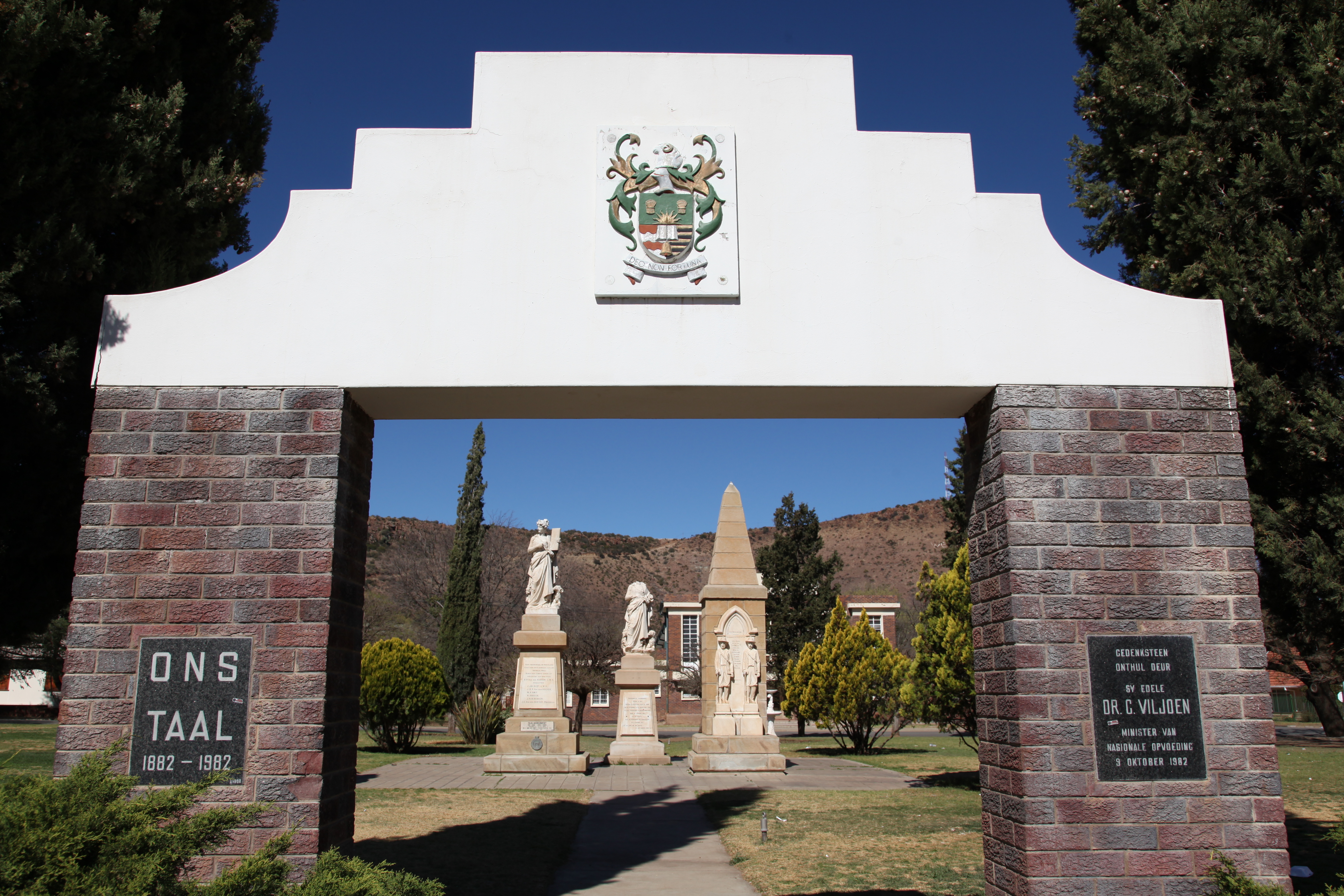
Afrikaans: Die Nederlandse taalmonument en Burgermonument in Burgersdorp, Oos-Kaap, Suid-Afrika
Met die 2de Britse besetting van die Kaap in 1806 het Engels die enigste ampstaal geword. Op 1 Mei 1882, d.i. 76 jaar later, is 'n wet deurgevoer wat Nederlands as Parlementstaal erken het. Op 15 Junie 1882 is Nederlands as taal van onderrig in skole toegelaat. Op die 26ste & 27ste Junie 1882 is die gebruik van Nederlands in Burgersdorp gevier, en Jotham Joubert het voorgestel dat 'n monument die geleentheid herdenk. Dit is op 18 Januarie 1893 onthul deur D.P. van den Heever, met S.J. du Toit wat die rede gelewer het. Tydens die boereoorlog het Britse soldate dit verniel en dele daarvan in King William’s Town begrawe. Lord Milner het die hele monument daarna verwyder, maar na protes het die Britte die dorp van 'n replika voorsien in 1907, wat op die 24ste & 25ste Mei 1907 onthul is, met redes deur President M.T. Steyn en outeur D.F. Malherbe. In 1939 is die oorspronklike opgespoor wat vanaf 1957 weer langs die kopie staan.[1] Aan die regterkant staan die Burgermonument wat op 10 Januarie 1908 onthul is deur genl. de la Rey. Dit gedenk een burger van Bethuli en 12 burgers van Burgersdorp wat in die Tweede Vryheidsoorlog gesneuwel het. English: The Dutch Language Monument in Burgersdorp, Eastern Cape, South Africa. The original of 1893, removed and vandalised by British forces during the Boer War, stands at center, while the replacement supplied by the British in 1907, stands at left.[1] On the right is the Burgher monument, unveiled in 1908, commemorating 13 burghers of the area that died during the Boer War.
|
| Date | |
| Source | Own work |
| Author | Rute Martins of Leoa's Photography (www.leoa.co.za) |
| Camera location | | View this and other nearby images on: OpenStreetMap |
|---|
Licensing edit
I, the copyright holder of this work, hereby publish it under the following licenses:
This file is licensed under the Creative Commons Attribution-Share Alike 3.0 Unported license.
- You are free:
- to share – to copy, distribute and transmit the work
- to remix – to adapt the work
- Under the following conditions:
- attribution – You must give appropriate credit, provide a link to the license, and indicate if changes were made. You may do so in any reasonable manner, but not in any way that suggests the licensor endorses you or your use.
- share alike – If you remix, transform, or build upon the material, you must distribute your contributions under the same or compatible license as the original.

|
Permission is granted to copy, distribute and/or modify this document under the terms of the GNU Free Documentation License, Version 1.2 or any later version published by the Free Software Foundation; with no Invariant Sections, no Front-Cover Texts, and no Back-Cover Texts. A copy of the license is included in the section entitled GNU Free Documentation License. |
You may select the license of your choice.
File history
Click on a date/time to view the file as it appeared at that time.
| Date/Time | Thumbnail | Dimensions | User | Comment | |
|---|---|---|---|---|---|
| current | 19:16, 23 November 2009 | | 5,616 × 3,744 (7.99 MB) | Leo za1 (talk | contribs) | {{Information |Description=Dutch Language Monument in Burgersdorp, Eastern Cape, South Africa |Source=self-made |Date=2009-09-12 |Author= Leo za1 |Permission= |other_versions= }} Category:Dutch Language Monument |
You cannot overwrite this file.
File usage on Commons
There are no pages that use this file.
File usage on other wikis
The following other wikis use this file:
- Usage on af.wikipedia.org
- Usage on cy.wikipedia.org
- Usage on en.wikipedia.org
- Usage on nl.wikipedia.org
- Usage on www.wikidata.org