File:Burned-out houses on Glenwood Avenue in the aftermath of the December 2022 blizzard, Buffalo, New York - 20230106.jpg

Size of this preview: 799 × 599 pixels. Other resolutions: 320 × 240 pixels | 640 × 480 pixels | 1,024 × 768 pixels | 1,280 × 960 pixels | 2,560 × 1,920 pixels | 3,049 × 2,287 pixels.
Original file (3,049 × 2,287 pixels, file size: 1.81 MB, MIME type: image/jpeg)
Captions
Captions
Add a one-line explanation of what this file represents
Summary edit
| Description |
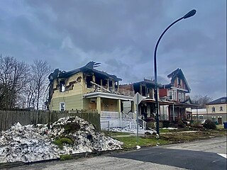
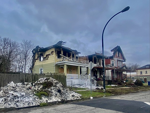
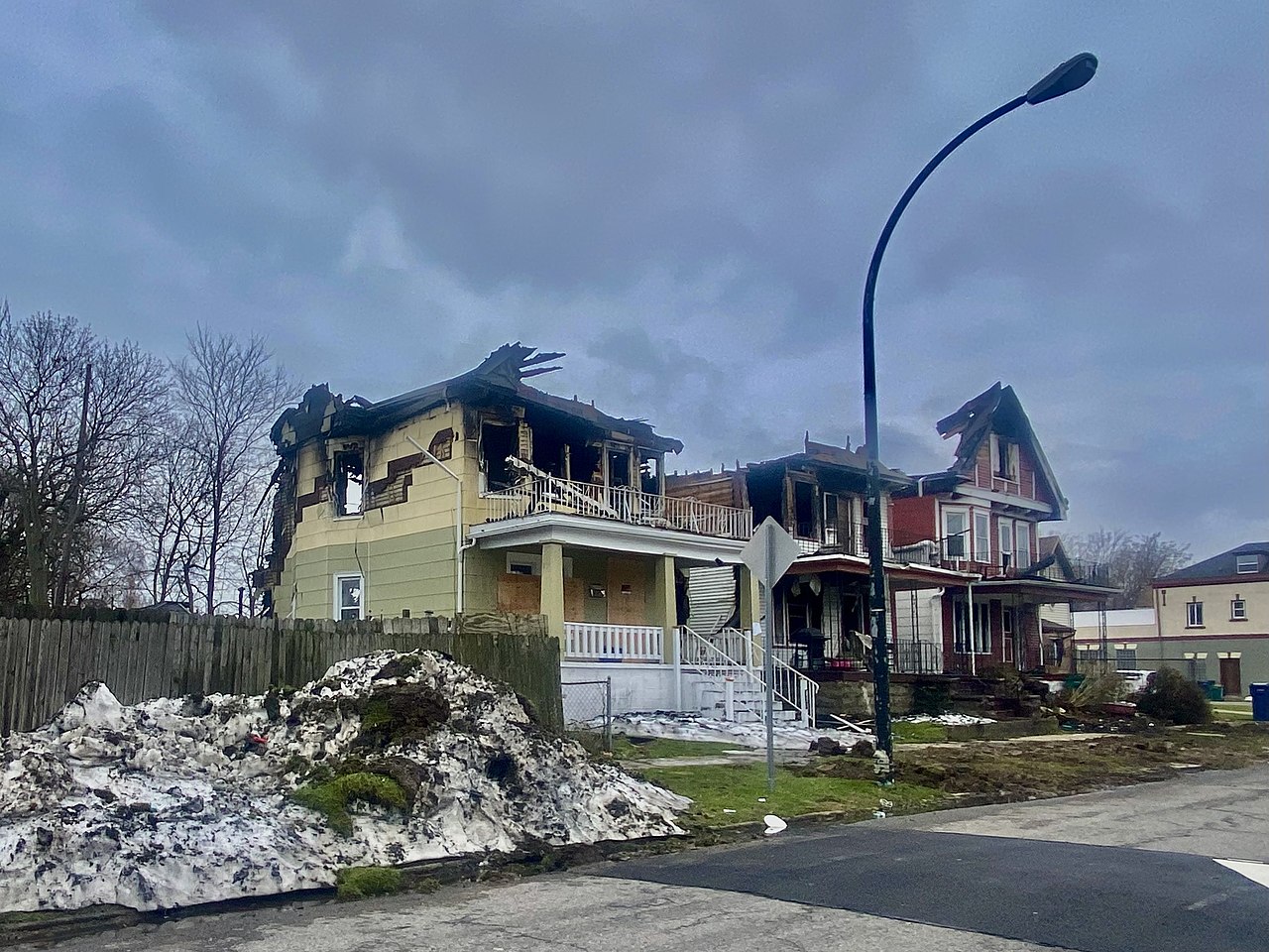
English: A trio of burned-out houses stand in ruins on the south side of Glenwood Avenue in Buffalo, New York, as seen on a January 2023 afternoon about two weeks after a historic blizzard that brought four feet of snow, hurricane-force winds, whiteout conditions, and 46 deaths to Buffalo and the surrounding suburbs: in the words of Erie County Executive Mark Poloncarz, "the worst storm in [the] community's history, surpassing the Blizzard of '77". However, among the most disastrous effects of the storm was the effect it had on emergency response services such as police, fire, and medical transportation: with the vast majority of police vehicles, fire apparatus, and ambulances stranded in the snow and unable to respond to calls, the storm saw the complete suspension of 911 service in Buffalo and the neighboring town of Cheektowaga for the first time in the history of the system. Indeed, seven of the 46 deaths occurred due to what officials characterized as delayed EMS response. That was true also in the case of these houses: fire trucks were ultimately able to reach the scene, but efforts to stop the blaze had to be scuttled when it was discovered the water in the firehoses was frozen. The apartments were occupied at the time of the blaze, but thankfully there were no deaths. The buildings were demolished about a week after this photo was taken. |
| Date | |
| Source | Own work |
| Author | Andre Carrotflower |
| Camera location | | View this and other nearby images on: OpenStreetMap |
|---|
Licensing edit
I, the copyright holder of this work, hereby publish it under the following license:
This file is licensed under the Creative Commons Attribution-Share Alike 4.0 International license.
- You are free:
- to share – to copy, distribute and transmit the work
- to remix – to adapt the work
- Under the following conditions:
- attribution – You must give appropriate credit, provide a link to the license, and indicate if changes were made. You may do so in any reasonable manner, but not in any way that suggests the licensor endorses you or your use.
- share alike – If you remix, transform, or build upon the material, you must distribute your contributions under the same or compatible license as the original.
File history
Click on a date/time to view the file as it appeared at that time.
| Date/Time | Thumbnail | Dimensions | User | Comment | |
|---|---|---|---|---|---|
| current | 07:06, 24 January 2023 | | 3,049 × 2,287 (1.81 MB) | Andre Carrotflower (talk | contribs) | Uploaded own work with UploadWizard |
You cannot overwrite this file.
File usage on Commons
There are no pages that use this file.