File:Bursa Yeşil Camii - Green Mosque (39).jpg
No higher resolution available.
Bursa_Yeşil_Camii_-_Green_Mosque_(39).jpg (774 × 478 pixels, file size: 157 KB, MIME type: image/jpeg)
Captions
Captions
Add a one-line explanation of what this file represents
Summary edit
.jpg&action=edit§ion=1)
| Description |
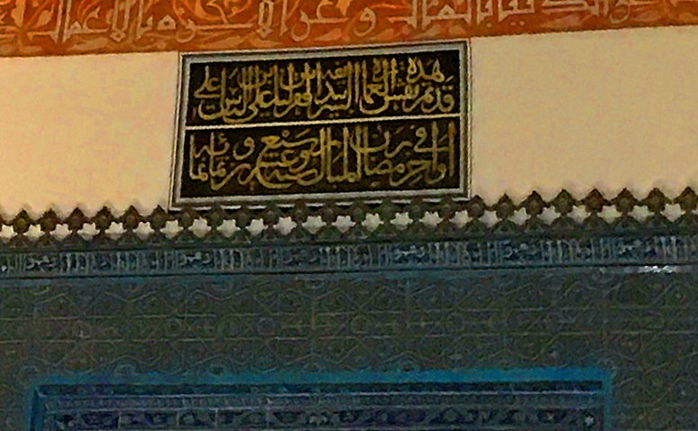
العربية: لوحة مكتوبة أعلى "مقصورة السلطان" داخل الجامع الأخضر، بورصة، تركيا. الجامع الأخضر، واسمه في تركيا "يشيل جامع"، ويُعرف أيضاً باسم "جامع السلطان محمد الأول" الذي أنشأ هذا المسجد بعد أن وَحَّدَ الدولة العثمانية عقب الحروب الأهلية (عهد الفترة) التي تلت موت أبيه السلطان بايزيد الأول في الأسر والتي استمرت 11 عاما. يقع الجامع الأخضر في الجانب الشرقي من مدينة بورصة التي كانت عاصمة العثمانيين حتى قبيل فتح القسطنطينية عام 1453م، والجامع جزء من كُلِّيّة أي مجموعة كبيرة من أبنية تتكون من مسجد ومقام ومدرسة ومطبخ عام وحمام عام. جائت التسمية "بالأخضر" نِسبة إلى استخدام اللون الأخضر في الزينة الداخلية للجامع والبلاط الأخضر على الجدران، وحاليا تم إضافة سجاد أخضر بالمسجد ليحافظ على الروح العامة للجامع
أما الفنانون الذين أنشأوا الزخارف فهم "علي بن إلياس علي" (بالتركية: Ali bin Ilyas) والمعروف باسم "النقّاش علي" (بالتركية: Nakkaş Ali) وذلك بحسب الكتابة الموجودة أعلى "مقصورة السلطان" (بالتركية: Hünkar mahfili) بداخل الجامع والتي تذكر أيضاً تاريخ انتهاء العمل من الزخارف (بالتقويم الهجري): - قد تم نقش هذه العمارة الشريفة بيد أفقر الناس علي بن إلياس علي - في أواخر رمضـــان المبارك سنــة سبع وعشــــرون وثمانمائـــة (وهو الموافق لعام 1424م) .Türkçe: Bursa Yeşil Camii, 2017. Bursa Yeşil Camii, Bursa’da ilk dönem Osmanlı mimarisinin önemli örnekleri arasında yer alan bir tarihi yapı. Caminin ünü, çini kaplamalarından gelir.
English: Green Mosque of Bursa, Turkey, 2017. Green Mosque (Turkish: Yeşil Camii, "Yeşil Mosque"), also known as Mosque of Sultan Mehmed I, is a part of the larger complex (a külliye) located on the east side of Bursa, Turkey, the former capital of the Ottoman Turks before they captured Constantinople in 1453. The complex consists of a mosque, türbe, madrasah, kitchen and bath. |
| Date | |
| Source | Own work |
| Author | Yahia.Mokhtar |
| Camera location | | View this and other nearby images on: OpenStreetMap |
|---|
.jpg¶ms=040.181983_N_0029.074614_E_globe:Earth_type:camera__&language=en)
Licensing edit
.jpg&action=edit§ion=2)
I, the copyright holder of this work, hereby publish it under the following license:
This file is licensed under the Creative Commons Attribution-Share Alike 4.0 International license.
- You are free:
- to share – to copy, distribute and transmit the work
- to remix – to adapt the work
- Under the following conditions:
- attribution – You must give appropriate credit, provide a link to the license, and indicate if changes were made. You may do so in any reasonable manner, but not in any way that suggests the licensor endorses you or your use.
- share alike – If you remix, transform, or build upon the material, you must distribute your contributions under the same or compatible license as the original.
File history
Click on a date/time to view the file as it appeared at that time.
| Date/Time | Thumbnail | Dimensions | User | Comment | |
|---|---|---|---|---|---|
| current | 18:19, 30 January 2018 | | 774 × 478 (157 KB) | "Yahia" (talk | contribs) | User created page with UploadWizard |
You cannot overwrite this file.
File usage on Commons
There are no pages that use this file.
File usage on other wikis
The following other wikis use this file:
- Usage on ar.wikipedia.org
.jpg&oldid=839457049)