File:Buskerud amt nr 36- Kart over Kongsberg, 1901.jpg

Size of this preview: 800 × 510 pixels. Other resolutions: 320 × 204 pixels | 640 × 408 pixels | 1,024 × 652 pixels | 1,280 × 816 pixels | 2,560 × 1,631 pixels | 9,967 × 6,351 pixels.
Original file (9,967 × 6,351 pixels, file size: 7.23 MB, MIME type: image/jpeg)
Captions
Captions
Add a one-line explanation of what this file represents
Summary edit
| Title |
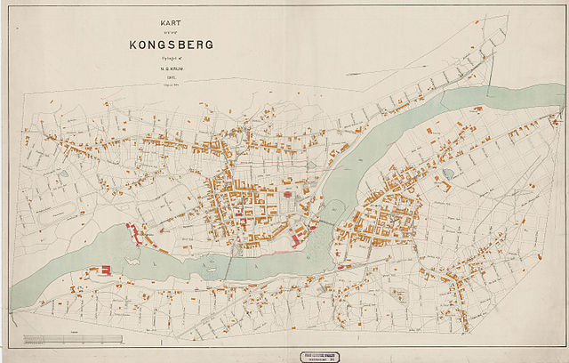
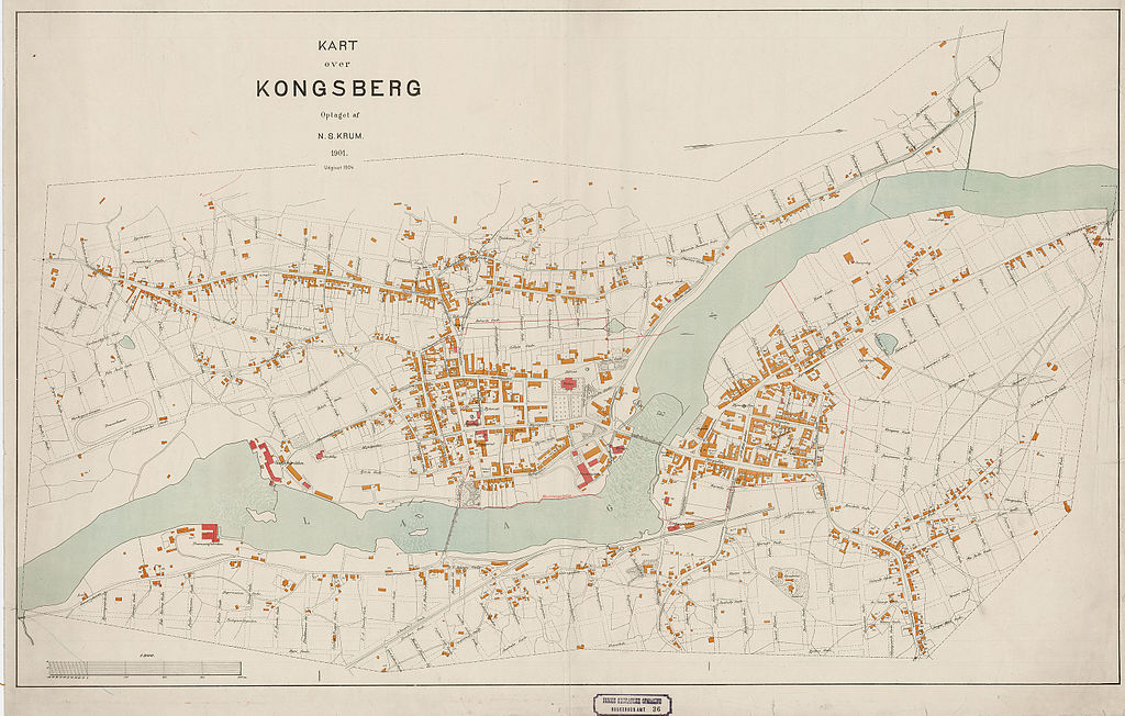
Norsk bokmål: Buskerud amt nr 36: Kart over Kongsberg, 1901 |
||||||||||||||||||||||||||
| Description |
Norsk bokmål: Kart over Kongsberg. |
||||||||||||||||||||||||||
| Date | |||||||||||||||||||||||||||
| Source |
|
||||||||||||||||||||||||||
| Creator |
N. S. Krum |
||||||||||||||||||||||||||
| Permission (Reusing this file) |
This file is licensed under the Creative Commons Attribution 4.0 International license.
|
||||||||||||||||||||||||||
| Geotemporal data | |||||||||||||||||||||||||||
| Date depicted | |||||||||||||||||||||||||||
| Map location | Buskerud,Kongsberg (Buskerud,Kongsberg) | ||||||||||||||||||||||||||
| Scale | 1:3,000 | ||||||||||||||||||||||||||
| Bounding box |
|
||||||||||||||||||||||||||
| Georeferencing | |||||||||||||||||||||||||||
| Bibliographic data | |||||||||||||||||||||||||||
| Part of the series | Category:Buskerud county | ||||||||||||||||||||||||||
| Map sheet | 36 | ||||||||||||||||||||||||||
| Language | Norwegian | ||||||||||||||||||||||||||
| Archival data | |||||||||||||||||||||||||||
| Collection |
|
||||||||||||||||||||||||||
| Accession number | |||||||||||||||||||||||||||
| Medium | lithograph lithography | ||||||||||||||||||||||||||
File history
Click on a date/time to view the file as it appeared at that time.
| Date/Time | Thumbnail | Dimensions | User | Comment | |
|---|---|---|---|---|---|
| current | 06:54, 29 October 2015 | | 9,967 × 6,351 (7.23 MB) | Artturimatias (talk | contribs) | GWToolset: Creating mediafile for Artturimatias. |
You cannot overwrite this file.
File usage on Commons
There are no pages that use this file.