File:CAPres1964.png
Size of this preview: 534 × 600 pixels. Other resolutions: 214 × 240 pixels | 633 × 711 pixels.
Original file (633 × 711 pixels, file size: 23 KB, MIME type: image/png)
Captions
Captions
Add a one-line explanation of what this file represents
Summary
edit
| Description |
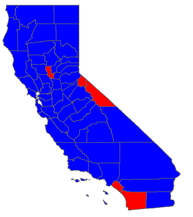
English: Map of election results by county in California for the 1976 U.S. Presidential election |
| Date | |
| Source | Own work (Original text: I created this work entirely by myself.) |
| Author | Socal gal at heart (talk) 22:28, 25 August 2008 (UTC) |
Licensing
edit
| This work has been released into the public domain by its author, Socal gal at heart at English Wikipedia. This applies worldwide. In some countries this may not be legally possible; if so: Socal gal at heart grants anyone the right to use this work for any purpose, without any conditions, unless such conditions are required by law. |
Original upload log
edit
The original description page was here. All following user names refer to en.wikipedia.
- 2008-08-25 22:28 Socal gal at heart 633×711 (23962 bytes) {{Information |Description=Map of election results by county in California for the 1976 U.S. Presidential election |Source=I created this work entirely by myself. |Date=08/25/2008 |Author=~~~~ |other_versions= }}
File history
Click on a date/time to view the file as it appeared at that time.
| Date/Time | Thumbnail | Dimensions | User | Comment | |
|---|---|---|---|---|---|
| current | 11:02, 24 December 2011 | | 633 × 711 (23 KB) | BotMultichillT (talk | contribs) | {{BotMoveToCommons|en.wikipedia|year={{subst:CURRENTYEAR}}|month={{subst:CURRENTMONTHNAME}}|day={{subst:CURRENTDAY}}}} == {{int:filedesc}} == {{Information |description={{en|1=Map of election results by county in California for the 1976 U.S. Presidential |
You cannot overwrite this file.
File usage on Commons
There are no pages that use this file.