File:CH-NB Photoglob-Wehrli EAD-WEHR-32035-B.tiff

Original file (4,658 × 3,542 pixels, file size: 15.77 MB, MIME type: image/tiff)
Captions
Captions
Summary edit
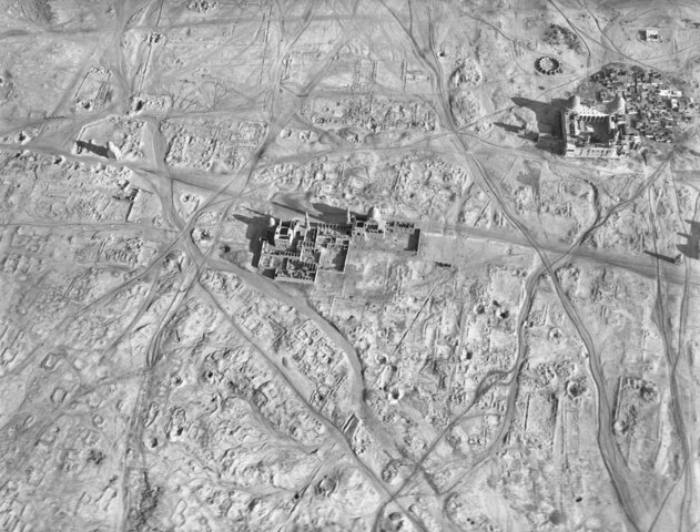
| Aegypten, Ortsteilansicht
( |
|||||||||||||||||||||||||||
|---|---|---|---|---|---|---|---|---|---|---|---|---|---|---|---|---|---|---|---|---|---|---|---|---|---|---|---|
| Photographer |
|
||||||||||||||||||||||||||
| Title |
Aegypten, Ortsteilansicht |
||||||||||||||||||||||||||
| Description |
Aegypten, Moschee El Aschraf und Moschee El Barkuk, umgeben von Krawanen-Wegen, Ballonaufnahme aus ca. 800 m Höhe |
||||||||||||||||||||||||||
| Depicted place | Ägypten | ||||||||||||||||||||||||||
| Date | 1904 | ||||||||||||||||||||||||||
| Medium | photograph | ||||||||||||||||||||||||||
| Dimensions | height: 18 cm (7 in); width: 24 cm (9.4 in) | ||||||||||||||||||||||||||
| Collection |
|
||||||||||||||||||||||||||
| Current location |
Prints and Drawings Department, Federal Archives of historic monuments |
||||||||||||||||||||||||||
| Accession number |
EAD-WEHR-32035-B |
||||||||||||||||||||||||||
| Notes | Published by Wehrli AG (1904-1924) [GND-ID 16137188-7] | ||||||||||||||||||||||||||
| Source | https://www.helveticarchives.ch/detail.aspx?id=162795 | ||||||||||||||||||||||||||
| Permission (Reusing this file) |
|
||||||||||||||||||||||||||
.jpg)


| Camera location | | View this and other nearby images on: OpenStreetMap |
|---|
Licensing edit
|
The author died in 1931, so this work is in the public domain in its country of origin and other countries and areas where the copyright term is the author's life plus 80 years or fewer. This work is in the public domain in the United States because it was published (or registered with the U.S. Copyright Office) before January 1, 1929. | |
| This file has been identified as being free of known restrictions under copyright law, including all related and neighboring rights. | |
File history
Click on a date/time to view the file as it appeared at that time.
| Date/Time | Thumbnail | Dimensions | User | Comment | |
|---|---|---|---|---|---|
| current | 08:49, 22 May 2014 |  | 4,658 × 3,542 (15.77 MB) | Swiss National Library (talk | contribs) | User created page with UploadWizard |
You cannot overwrite this file.
File usage on Commons
The following 4 pages use this file: