File:CROMER'S MILL COVERED BRIDGE.jpg

Size of this preview: 800 × 519 pixels. Other resolutions: 320 × 207 pixels | 640 × 415 pixels | 1,024 × 664 pixels | 1,280 × 830 pixels | 2,560 × 1,659 pixels | 5,238 × 3,395 pixels.
Original file (5,238 × 3,395 pixels, file size: 2.03 MB, MIME type: image/jpeg)
Captions
Captions
Add a one-line explanation of what this file represents
Summary edit
| Description |
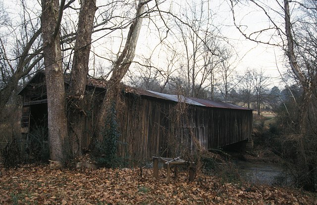
English: Cromer's Mill Covered Bridge; 1906 town truss over Nails Creek; 110 feet long.
|
||
| Date | |||
| Source | Own work | ||
| Author | JERRYE & ROY KLOTZ MD |
| Object location | | View this and other nearby images on: OpenStreetMap |
|---|
Licensing edit
I, the copyright holder of this work, hereby publish it under the following license:
This file is licensed under the Creative Commons Attribution-Share Alike 3.0 Unported license.
- You are free:
- to share – to copy, distribute and transmit the work
- to remix – to adapt the work
- Under the following conditions:
- attribution – You must give appropriate credit, provide a link to the license, and indicate if changes were made. You may do so in any reasonable manner, but not in any way that suggests the licensor endorses you or your use.
- share alike – If you remix, transform, or build upon the material, you must distribute your contributions under the same or compatible license as the original.
File history
Click on a date/time to view the file as it appeared at that time.
| Date/Time | Thumbnail | Dimensions | User | Comment | |
|---|---|---|---|---|---|
| current | 14:31, 25 November 2012 | | 5,238 × 3,395 (2.03 MB) | Cropbot (talk | contribs) | upload cropped version, operated by User:Finavon. Summary: border cropped |
| 00:07, 3 November 2012 |  | 5,782 × 3,946 (2.34 MB) | KLOTZ (talk | contribs) | User created page with UploadWizard |
You cannot overwrite this file.
File usage on Commons
The following page uses this file:
File usage on other wikis
The following other wikis use this file:
- Usage on de.wikipedia.org
- Usage on en.wikipedia.org
- Usage on www.wikidata.org
- Usage on zh.wikipedia.org