File:CSX map.svg

Size of this PNG preview of this SVG file: 800 × 475 pixels. Other resolutions: 320 × 190 pixels | 640 × 380 pixels | 1,024 × 608 pixels | 1,280 × 760 pixels | 2,560 × 1,520 pixels | 1,152 × 684 pixels.
Original file (SVG file, nominally 1,152 × 684 pixels, file size: 2.31 MB)
Captions
Captions
Add a one-line explanation of what this file represents
Summary edit

|
This file has been superseded by CSX Transportation system map.svg. It is recommended to use the other file. Please note that deleting superseded images requires consent.
|

|
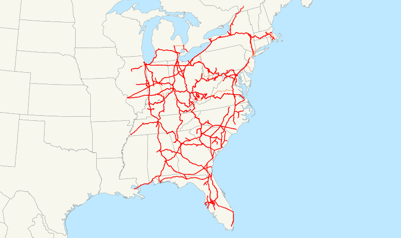
This is a map of the CSX rail network. Only selected trackage rights are shown.
The following GIS data was used:
- sample data included with ArcGIS for state and provincial boundaries
- NORTAD archive copy at the Wayback Machine for Canadian rail lines
- 2006 National Transportation Atlas Database archive copy at the Wayback Machine for U.S. rail lines
A standard North American Lambert conformal conic projection was used.
Various sources, including the NTAD data, were used to determine where CSX operates. There may be errors; additionally most minor branches are not shown.
Licensing edit
| I, the copyright holder of this work, release this work into the public domain. This applies worldwide. In some countries this may not be legally possible; if so: I grant anyone the right to use this work for any purpose, without any conditions, unless such conditions are required by law. |
File history
Click on a date/time to view the file as it appeared at that time.
| Date/Time | Thumbnail | Dimensions | User | Comment | |
|---|---|---|---|---|---|
| current | 04:30, 29 November 2006 | | 1,152 × 684 (2.31 MB) | NE2 (talk | contribs) | Made a few corrections. |
| 22:11, 20 November 2006 |  | 1,152 × 684 (2.32 MB) | NE2 (talk | contribs) | Maybe if I use simpler boundary data it will create thumbnails properly. | |
| 21:45, 20 November 2006 |  | 1,152 × 684 (10.03 MB) | NE2 (talk | contribs) | Uploading a better version. | |
| 18:32, 19 November 2006 |  | 1,152 × 684 (4.3 MB) | NE2 (talk | contribs) | This is a map of the CSX rail network. It's not yet completed. == Licensing == {{PD-self}} Category:Maps |
You cannot overwrite this file.
File usage on Commons
There are no pages that use this file.
File usage on other wikis
The following other wikis use this file:
- Usage on en.wikipedia.org